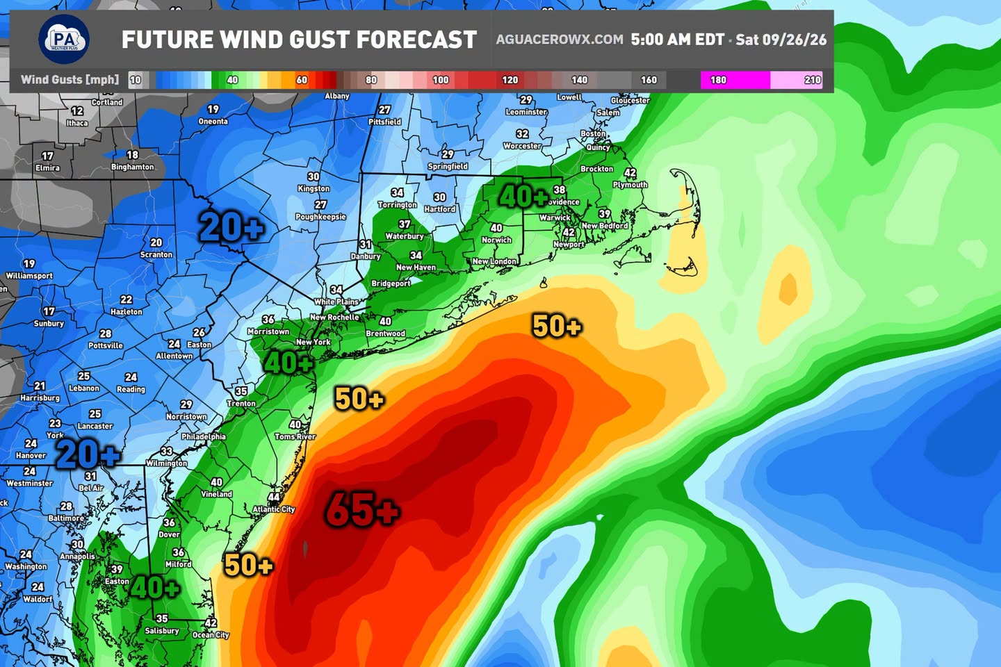
NEW YORK, NY — A developing Nor’easter will bring increasing impacts across the East Coast on Saturday and Sunday, with wind gusts climbing to 40 mph along the Interstate 95 corridor and considerably stronger winds expected at the shorelines, where gusts could reach 50 mph or more. The strongest winds associated with the storm will remain well offshore, but could reach as high as 65 mph in the open ocean waters, generating high wave heights that combine with persistent onshore flow to produce impactful coastal flooding.
Wind Gusts Intensify From Inland to Coast
Forecast graphics show a clear gradient in expected wind gusts as the storm approaches, with inland areas along the I-95 corridor seeing gusts around 40 mph, while coastal communities including New York, New Haven, and Atlantic City face considerably stronger gusts in the 50 mph range. The most extreme winds, reaching 65 mph or higher, are forecast well offshore, though this open-water wind field is what drives the elevated wave heights ultimately affecting the coastline itself.
This kind of escalating wind pattern moving from inland areas toward the coast and out to sea is typical of a Nor’easter drawing its strength from the temperature contrast between cold air over land and the relatively warmer ocean waters offshore.
Persistent Onshore Flow Raises Coastal Flooding Risk
The combination of strong offshore winds and sustained onshore flow is expected to be the primary driver of coastal flooding concerns associated with this storm. As wind consistently pushes water toward the coastline over an extended period, water levels can build beyond what a single high tide cycle alone would produce, creating conditions favorable for impactful flooding in vulnerable coastal areas throughout the affected region.
Forecasters note that this persistent onshore push, rather than any single dramatic surge, is what makes the coastal flooding threat from this system worth monitoring closely as the weekend approaches.
Widespread Rainfall Expected Along the Coast
Beyond the wind and coastal flooding concerns, the storm is also forecast to bring significant rainfall to areas along the coast. The most recent European model run shows widespread rainfall totals of 1 to 3 inches expected along coastal areas, with locally higher amounts possible in some locations. Isolated totals of 3 to 5 inches could occur depending heavily on the storm’s exact track, with communities including Providence, New Bedford, and coastal Massachusetts highlighted among the areas seeing the heaviest projected totals.
The same model guidance also brings measurable rain farther inland into eastern Pennsylvania, an area that will need continued monitoring as the storm’s track becomes clearer in the coming days.
Not Expected to Be an Extreme or Historic Event
Despite the significant winds and rainfall associated with this system, forecasters are directly pushing back against comparisons to major historic storms, emphasizing that this event is not expected to be a hurricane, a repeat of Superstorm Sandy, or anything out of the ordinary or extreme for the season. While impacts will still occur and could meaningfully affect weekend plans across the region, storms of this general nature are considered common during the autumn and winter months along the East Coast.
Residents across the affected region are encouraged to prepare for a blustery, wet weekend with the potential for coastal flooding in vulnerable areas, while keeping the overall scale of the event in proper perspective as a routine, if impactful, seasonal Nor’easter rather than an exceptional weather disaster.
For continuing coverage of severe weather events and critical storm analysis across the United States, visit diamondprowl.com.