HARTFORD, CT — A slow-moving nor’easter kept pounding Connecticut Saturday evening, and forecasters warned the roughest part of the storm was still to come. The center of the storm was drifting north and was expected to move closer to the state over several hours before it weakened. Strong wind, more rain and a high-tide coastal flooding threat were all set to peak from Saturday evening until about 2 to 4 a.m. Gusts had already reached 40 mph in spots, and about 21,000 customers were without power as of the 5 p.m. update.
Wind Gusts Expected to Top 50 MPH Along the Coast
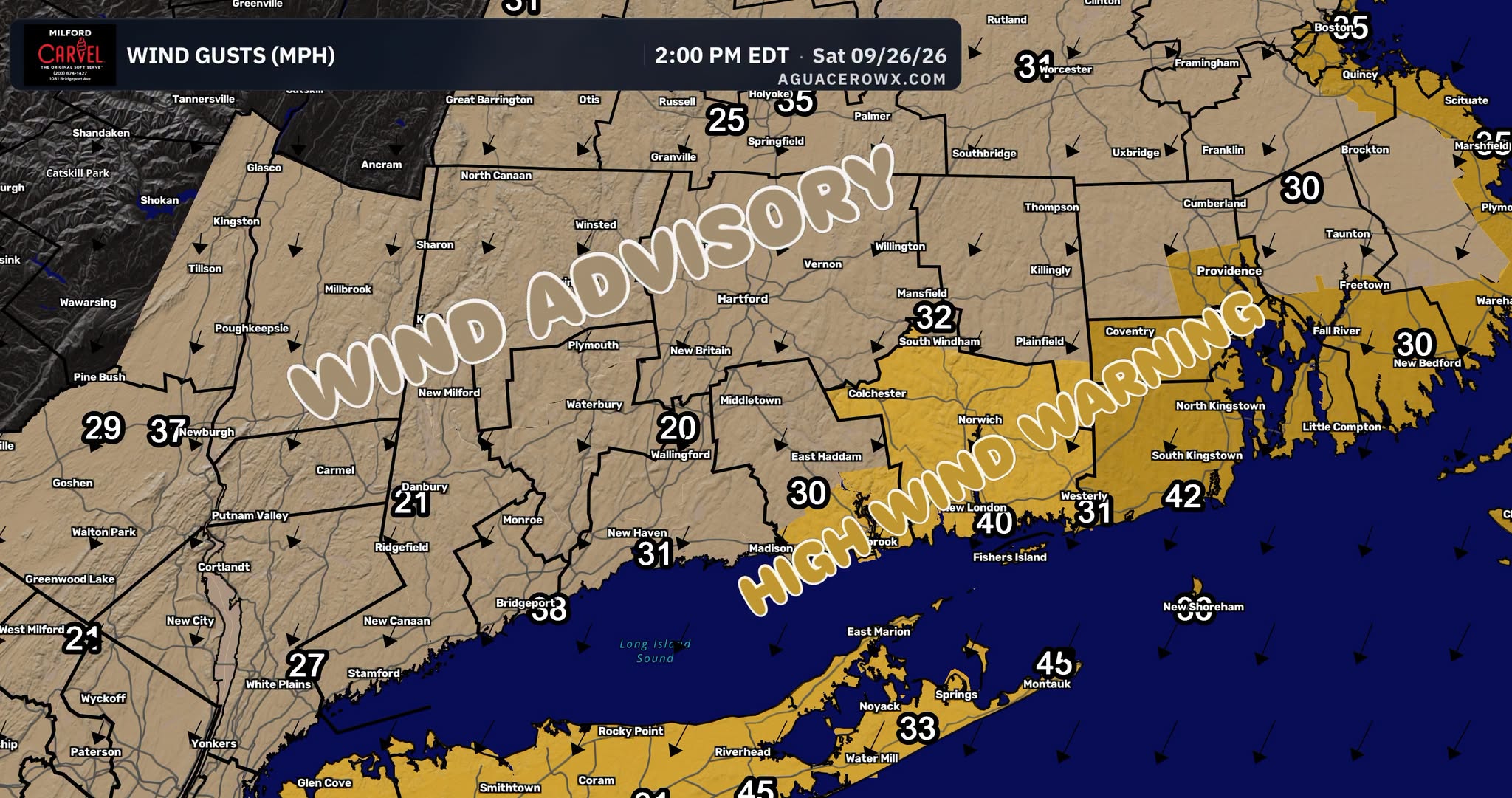
Gusts were forecast to strengthen again Saturday night and could top 50 mph, especially along the Connecticut shoreline. Earlier wind data from 2 p.m. already showed strong gusts across the region. The strongest readings were 45 mph near Montauk, 42 mph near Westerly, Rhode Island, 40 mph at New London and 38 mph near Bridgeport. Inland, gusts of 31 mph were recorded at New Haven, 32 mph near Mansfield and about 30 mph near East Haddam.
With the ground already wet and trees still in full leaf, those stronger gusts could bring down more limbs and power lines overnight. Utility crews may face new outages even as they work to restore the 21,000 customers already in the dark.
High Wind Warning and Wind Advisory Cover the Region
The storm brought a split set of alerts across southern New England and New York. A High Wind Warning covered the eastern Connecticut coastline, including New London County from about Norwich to the Rhode Island border, along with much of coastal and southern Rhode Island and the eastern end of Long Island. That included the North Fork, the South Fork and Montauk. The strongest winds were expected in these exposed coastal areas.
A Wind Advisory covered the rest of Connecticut, from Fairfield County and New Haven County through Hartford, Litchfield County and Tolland County. It also reached into parts of southeastern New York, including the Hudson Valley, and into central Massachusetts. Travelers on high-profile vehicles and anyone near large trees should be especially careful overnight.
More Rain on the Way East of Interstate 91
On top of the wind, more rain was expected to move through Saturday night, especially east of Interstate 91. That puts eastern Connecticut, including Middlesex, New London, Tolland and Windham counties, in line for the heaviest remaining rain.
Heavy rain combined with fallen leaves can clog storm drains and cause ponding on roads. Drivers should slow down, watch for standing water and never drive through flooded roadways. Downed limbs across local roads may add to travel problems after dark.
Evening High Tide Remains the Biggest Concern
The main concern throughout the storm has been coastal flooding. The evening high tide, expected between about 9:45 p.m. and 12:30 a.m. along the Connecticut shoreline, was forecast to run higher than Saturday morning’s tide. That tide lines up with the stronger onshore winds, which raises the risk of water pushing into flood-prone shoreline neighborhoods, low-lying roads and waterfront parking areas along Long Island Sound.
Communities from Stamford and Bridgeport through New Haven, Madison, Old Saybrook and New London should be ready for possible flooding at the waterfront during high tide. Residents in areas that flood easily should move vehicles to higher ground ahead of high tide and avoid walking or driving through saltwater flooding.
A Storm That Matched the Forecast
Some residents who spent the day at home may wonder whether this was really the storm they were warned about. It was. For three days, the forecast had called for an “at times” rainy and windy Saturday, and coastal flooding was always the main threat. It was never a nonstop, all-day washout. The storm played out as expected: bursts of rain and wind, scattered outages and a building tidal threat into the night.
Storm to Weaken After Early Sunday Morning
Conditions were expected to improve after about 2 to 4 a.m. Sunday, when the nor’easter was forecast to start weakening. Until then, residents across Connecticut, Rhode Island and eastern Long Island should stay alert for gusty winds, more power outages, heavy rain east of I-91 and flooding around the late-evening high tide. Keep phones charged, keep flashlights handy and report downed wires to your utility right away.
For continuing coverage of this nor’easter and weather developments across the Northeast and the United States, visit diamondprowl.com.