DEL RIO, TX — A strong thunderstorm was moving south toward Del Rio Monday night. It threatened the city and nearby communities in Val Verde County with very small hail, wind gusts up to 40 mph and plenty of lightning. The storm was tracked on radar around 9:05 p.m., with its most intense cores sitting just north of town and pushing toward the Rio Grande border region. Residents in and around Del Rio, Lake View and Laughlin Air Force Base were urged to move indoors and stay alert as the storm arrived.
Radar Shows Intense Cores North of Del Rio
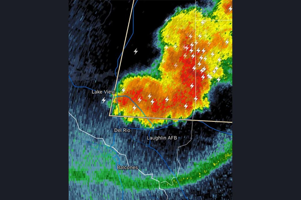
Radar reflectivity near 9:04 p.m. showed a large area of heavy rain and storm activity north and northeast of Del Rio. The brightest red and orange returns marked the strongest parts of the storm. One intense core sat over and just east of Lake View, and a broader cluster of heavy returns stretched northeast of Laughlin AFB.
The southern edge of the storm was pressing close to the north side of Del Rio, which put the city directly in line for the incoming weather. Heavy rain, gusty winds and small hail were expected to spread across town as the storm kept moving south.
Frequent Lightning Across the Storm
One of the most striking features on radar was the dense cluster of lightning strikes across the storm. Numerous strikes showed up in the heaviest cores northeast of Laughlin AFB. More lightning appeared over the western part of the storm near Lake View and just north of Del Rio.
Lightning is one of the most dangerous parts of any thunderstorm, and it can strike miles ahead of the heavy rain. Anyone outdoors in Del Rio, near Lake Amistad or along the Rio Grande should get inside a sturdy building or a hard-topped vehicle right away. The old rule still applies: when thunder roars, go indoors, and wait at least 30 minutes after the last thunder before going back outside.
Very Small Hail and 40 MPH Gusts Possible
The storm could produce very small hail as it moves across the Del Rio area. While hail of that size usually isn’t enough to cause major damage, it can still make roads slick, cut visibility and cause minor damage to plants and exposed objects.
Wind gusts up to 40 mph were also possible. Gusts that strong can knock down small tree limbs, scatter loose outdoor items such as patio furniture, trash cans and decorations, and cause brief power flickers. Anyone with loose items in their yard should secure them or bring them inside, and drivers of high-profile vehicles should be careful on open stretches of highway.
Laughlin AFB and Surrounding Communities in the Path
Laughlin Air Force Base, east of Del Rio, sat right along the southern edge of the storm’s heavier activity. As the storm moved south, the base and nearby neighborhoods were expected to get gusty winds, heavy downpours and lightning.
Farther south, communities near Balcones and along the Rio Grande could also see storm effects if the line keeps its strength. Radar also showed a separate band of lighter returns stretching east to west south of Del Rio, marking another area of disturbed weather across the border region.
Travel and Safety Concerns Tonight
Drivers on U.S. Highway 90 and U.S. Highway 277 near Del Rio should be ready for sudden drops in visibility from heavy rain and possible small hail. Wet roads, strong crosswinds and lightning can make nighttime driving especially dangerous. If heavy rain makes it hard to see, slow down, turn on your headlights and leave extra space between vehicles.
Low spots and poorly drained streets in Del Rio may collect water quickly under heavy downpours. Never drive through flooded roads, since the water can be deeper and faster than it looks, especially in the dark.
What Comes Next for Val Verde County
The storm was moving south, so its effects on Del Rio were expected to be fairly short-lived as the heaviest cores moved through and on toward the border. Even after the strongest part of the storm passes, lingering lightning and light to moderate rain could continue for a while.
Residents across Val Verde County should keep a charged phone nearby, have Wireless Emergency Alerts turned on, and watch updates from the National Weather Service office serving the area. Storms in South Texas can strengthen quickly, so it’s important to stay alert until the storm has fully cleared.
For continuing coverage of storms and weather developments across Texas and the United States, visit diamondprowl.com.