PORTLAND, OR — A compact but potent mid-latitude cyclone is forecast to approach the northwest Oregon coast early Friday morning, potentially bringing a localized windstorm to the region and possibly extending impacts into Washington state. While the storm is not expected to feature extremely low pressure, forecasters say the pressure gradient on the south and west side of the system will likely produce reasonably strong winds, with 60 mph gusts possible in localized coastal locations.
Storm Track Points Toward Northwest Oregon Coast
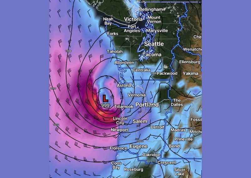
Current forecast guidance suggests the low pressure system will most likely make landfall somewhere along the northwest Oregon coast while continuing to track east-northeast into the interior. A graphic showing the European model’s depiction of the storm at 9 AM Friday displays the low positioned just offshore near Tillamook and Lincoln City, with a central pressure around 999 millibars and a tightly wound pressure gradient extending across the coastal waters.
The strongest winds associated with this system are expected to be concentrated directly south and west of the surface low as it approaches the coastline, a typical wind distribution pattern for storms of this configuration tracking onto the Pacific Northwest coast.
Winds Expected to Spread Inland
Following landfall, forecasters expect winds to spread inland across the Willamette Valley and into the Cascades. Current projections show 60 mph gusts as possible for localized spots directly along the Oregon coast, while the Willamette Valley and far southwest Washington could see gusts in the 40 to 50 mph range as the system moves through during the morning and midday hours.
Gusty winds are then expected to spread across eastern Washington later in the day, with 40 to 45 mph gusts possible during the afternoon and evening hours as the broader wind field associated with the storm continues its eastward progression across the region.
Washington’s Exact Impacts Remain Uncertain
Forecasters caution that there remains a real possibility the low pressure system could track somewhat farther north than currently expected, a shift that would meaningfully change which parts of Washington state experience the most disruptive winds. Every small detail in the storm’s eventual track and depth will influence both how disruptive the event becomes and precisely where those impacts are concentrated, making this a forecast worth continued close monitoring in the days ahead.
Should the low end up deeper and track farther north than current guidance suggests, it could become more disruptive for a wider swath of Washington, though as of now, far southwest Washington appears most likely to see the brunt of any wind impacts extending north of the Oregon border.
Elevated Tree Damage Risk Given Timing
Because this storm is arriving in September while trees across the region remain fully leafed out, forecasters note that wherever the strongest winds ultimately occur, the event will likely produce more tree damage than a similar-strength storm would cause later in the fall or winter once trees have shed their leaves. Fully leafed trees catch significantly more wind resistance than bare branches, increasing the likelihood of downed limbs and uprooted trees even from winds that might otherwise cause limited damage during the dormant season.
Not Expected to Be a Major Regional Windstorm
Despite the potential for localized impacts, forecasters are clear that this system is not shaping up to be a large, regional, major windstorm affecting the entire Pacific Northwest. Rather, isolated locations could experience problems worth paying attention to, even as the broader event remains modest in scale compared to significant historical windstorms that have affected the region. On the positive side, the same system is expected to deliver a healthy amount of beneficial rainfall to Washington state alongside the wind concerns.
For continuing coverage of severe weather events and critical storm analysis across the United States, visit diamondprowl.com.