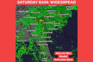
ATLANTA, GA — Heavy rain will bring a risk of flooding to north Georgia and Alabama this weekend. Much of the region is expected to get 1 to 2 inches of rain. Isolated totals of 4 inches or more are possible, and they could lead to localized flooding. The flood threat peaks Saturday into Saturday night. The highest risk covers northwest Georgia, including Rome and Calhoun, and a band across northern and central Alabama from Huntsville to Birmingham. The Atlanta metro area and surrounding communities fall under a lower but still notable threat.
Low Flood Threat for Northwest Georgia
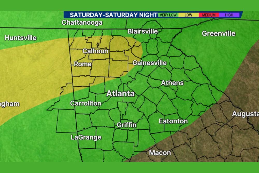
The Saturday and Saturday night flood threat map shows a low risk across northwest Georgia. The highlighted area includes Rome, Calhoun and the surrounding counties, stretching northeast toward Blairsville and the western edge of the Gainesville area. That covers parts of the North Georgia Mountains, where heavy rain can quickly send runoff into creeks and streams.
Communities in Floyd, Gordon, Bartow, Cherokee, Pickens, Gilmer, Dawson and Lumpkin counties are inside or near this higher-risk zone. Residents there should be alert for rising water, especially in low-lying areas and near small streams.
Alabama Under a Low Flood Risk
The low flood threat also extends west across northern and central Alabama. The highlighted band runs from the Huntsville area southwest past Birmingham and continues toward western Alabama. That puts communities across the Tennessee Valley, the I-20/59 corridor and much of north-central Alabama at risk of heavy downpours and localized flooding.
Urban areas around Birmingham and Huntsville could see street flooding where drainage systems get overwhelmed during periods of heavy rain.
Atlanta Metro Faces a Very Low Flood Threat
The Atlanta metro area falls under a very low flood threat for Saturday and Saturday night. The same is true for Carrollton, LaGrange, Griffin, Gainesville, Athens and Eatonton. Even though the risk is lower, heavy rain could still cause ponding on roads, slow traffic and wet weekend plans across the metro.
Farther north, the very low risk extends into Chattanooga, Tennessee, and toward Asheville, North Carolina, and Greenville, South Carolina. The risk drops off farther south and east, including the Macon and Augusta areas, which sit outside the main flood threat zone.
Rain Totals of 1 to 2 Inches Expected
Most of the region is expected to get 1 to 2 inches of rain through the weekend. That’s enough to soak lawns, fill gutters and create slick roads, but it usually doesn’t cause widespread flooding by itself.
The bigger concern comes from isolated 4-inch-plus totals. Where heavier storms stall or move repeatedly over the same areas, rain could pile up quickly and cause localized flooding of roads, creeks and poorly drained neighborhoods.
Weekend Plans May Need Adjusting
With the heaviest rain expected Saturday into Saturday night, outdoor events across north Georgia and Alabama could be affected. That includes high school and college football games, festivals, tailgates and fall activities. Fans heading to games should bring rain gear and allow extra travel time.
Drivers on Interstate 75, Interstate 85, Interstate 20 and Interstate 65 should be ready for heavy downpours, reduced visibility and slower traffic.
Flood Safety Reminders
Residents should clear gutters and storm drains before the rain arrives and move vehicles away from flood-prone spots. Make sure phones can receive Wireless Emergency Alerts. Most importantly, never drive through flooded roadways. Just 12 inches of moving water can sweep away most vehicles. Turn around, don’t drown.
For continuing coverage of the weekend flood threat and weather developments across Georgia, Alabama and the United States, visit diamondprowl.com.