

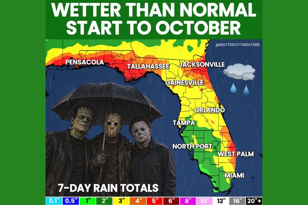
TALLAHASSEE, FL — Florida is heading into a wetter-than-normal start to October, with multiple rounds of rain and storms expected across the state over the next one to two weeks. The latest 7-day rainfall totals show the heaviest amounts across the Florida Panhandle and the northern half of the state. Some of the hardest-hit areas could see 6 inches or more. The wet pattern may also be an early preview of the wet El Niño winter forecasters expect for Florida this season.
Panhandle and North Florida Take the Brunt
The 7-day rainfall map shows the heaviest totals across the Florida Panhandle, where much of the region falls in the 4 to 5 inch range. The Pensacola and Tallahassee areas sit inside a broad band of heavy rain, with pockets of 5 inches or more along the Gulf Coast and inland counties.
Heavy rain also stretches across northeast Florida. The Jacksonville area and the First Coast show totals of around 4 to 5 inches, with some of the highest amounts near the Atlantic coastline. In the hardest-hit areas of north Florida, 6-inch-plus totals can’t be ruled out.
Central Florida Sees Moderate Totals
Across central Florida, rain totals are expected to be lighter but still significant. The Gainesville, Orlando and Tampa areas fall mostly in the 2 to 3 inch range over the next seven days. Some spots along the east coast of central Florida could see 3 to 4 inches.
These amounts are enough to soak lawns, raise water levels in retention ponds and cause ponding on roads during heavier downpours, especially during afternoon and evening storms.
Southeast Coast Also Turns Wet
The southeast Florida coast has another area of heavier rain. The West Palm Beach area shows totals near 4 to 5 inches, and nearby coastal areas along the Treasure Coast could see 3 to 4 inches.
Farther south, Miami and much of South Florida show more moderate totals of about 2 to 3 inches. Southwest Florida, including North Port, Fort Myers and the area south of Tampa Bay, shows the lightest totals in the state, mostly near 1 to 2 inches.
Multiple Rounds Over One to Two Weeks
This won’t be one big storm. It’s expected to be a prolonged wet pattern, with several rounds of rain and thunderstorms moving across Florida over the next one to two weeks. Repeated heavy rain over the same areas could saturate the ground, making flooding more likely with each new round.
Residents should expect some days with steady rain and others with scattered thunderstorms, gusty winds and lightning. The rain could affect commutes, outdoor events and weekend plans across the state.
A Preview of the El Niño Winter
The wet start to October may be foreshadowing the season ahead. A strengthening El Niño usually brings a more active southern storm track during the cool season, which often means wetter-than-normal conditions across Florida and the Gulf Coast during winter.
Seasonal outlooks already favor above-normal precipitation for Florida this winter, and the early-October rain pattern fits that trend.
Flood Safety Tips
With heavy rain expected over several days, residents should clear gutters and storm drains, avoid driving through flooded streets and watch for rising water in low-lying neighborhoods. Remember that just 12 inches of moving water can sweep away most vehicles. Turn around, don’t drown.
For continuing coverage of Florida’s wet October pattern and weather developments across the United States, visit diamondprowl.com.