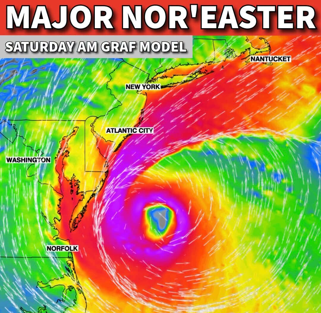
NEW YORK, NY — The first major Nor’easter of the season is set to batter the East Coast this Saturday, with the powerful storm featuring a hurricane-like eye and producing hurricane-force wind gusts up to 90 mph offshore along with seas building to as high as 30 feet. Coastal cities from the Mid-Atlantic through the Northeast are bracing for a significant pounding from both wind and water as the storm tracks close to the coastline over the weekend.
A Storm With Hurricane-Like Characteristics
Meteorological model imagery shows the developing Nor’easter displaying a remarkably well-organized structure, complete with a clearly defined eye-like feature at its center surrounded by intense wind fields spiraling outward, characteristics typically associated with tropical systems rather than traditional Nor’easters. This hurricane-like presentation reflects just how powerful and remarkably well-organized the storm has become as it approaches the East Coast, with the Saturday morning model run depicting the system positioned offshore between New Jersey and North Carolina.
The storm’s structure, combined with the extreme wind and sea state values associated with it, underscores the significant potential for this system to produce impacts more commonly associated with tropical cyclones than typical late-season Nor’easters affecting the region.
Hurricane Force Gusts and Massive Seas Offshore
Forecasters are highlighting hurricane-force wind gusts reaching up to 90 mph as one of the most significant hazards associated with this storm, with these extreme winds expected primarily over open water offshore rather than directly over populated coastal areas. Alongside the powerful winds, ocean seas are forecast to build to as high as 30 feet in the most intense portions of the storm, creating extremely hazardous conditions for any marine traffic operating in the vicinity of the system as it tracks along the coast.
This combination of hurricane-force gusts and towering seas represents a genuinely dangerous offshore environment, even as the most extreme conditions remain concentrated over open water rather than directly impacting the immediate coastline.
Coastal Cities Brace for Wind and Water Impacts
Communities stretching from Norfolk and Hatteras northward through Atlantic City, New York, and Nantucket are positioned within reach of the storm’s broader wind field and associated impacts. While the most extreme wind and wave conditions are expected to remain offshore, coastal cities throughout this stretch of the East Coast should still anticipate a significant pounding from both wind and water as the Nor’easter tracks through the region over the weekend, given the storm’s overall size and intensity.
Residents and local officials in these coastal communities are advised to prepare for potential coastal flooding, beach erosion, and disruptive winds as the storm makes its closest approach to the coastline during the height of the weekend event.
A Silver Lining for Florida
While the Northeast and Mid-Atlantic brace for the Nor’easter’s impacts, the same overall weather pattern is delivering a welcome gift to Florida in the form of an early-season cold front. This front is expected to drop temperatures into the 60s across roughly two-thirds of the state, accompanied by low humidity during the Saturday and Sunday morning hours, offering Florida residents a rare and refreshing taste of cooler, more comfortable conditions even as the powerful storm batters the East Coast farther north.
The contrast between the two weather stories playing out simultaneously across the eastern United States this weekend illustrates the broad reach of the larger atmospheric pattern driving both events. The same storm system and associated cold air mass responsible for fueling the powerful Nor’easter off the coast is also helping usher in the season’s first significant cool down across the Florida peninsula, a reminder of how interconnected weather patterns can be across such a wide and varied geographic area of the country.
What to Expect Through the Weekend
As the Nor’easter continues to intensify and track along the East Coast, coastal residents from the Carolinas through New England should closely monitor updated forecasts throughout the weekend, given the storm’s hurricane-like characteristics and the potential for conditions to evolve as the system makes its closest pass. Meanwhile, Florida residents can look forward to enjoying the unusually comfortable early fall conditions, a welcome change after what has been an extended stretch of typical late-summer heat and humidity across much of the state this year.
For continuing coverage of severe weather events and critical storm analysis across the United States, visit diamondprowl.com.