

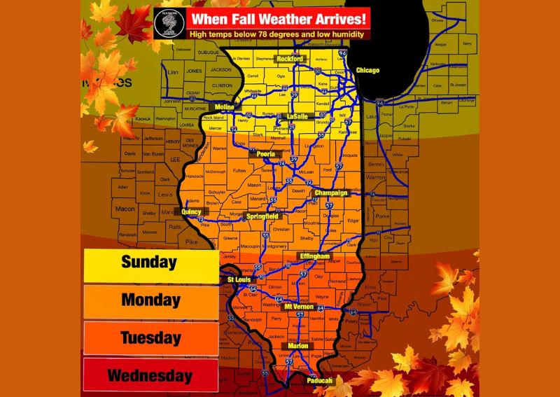
ROCKFORD, IL — Fall-like weather is set to arrive across Illinois on a staggered timeline this week, with northern Illinois communities including Rockford, Chicago, and LaSalle seeing the first taste of the cooler pattern as early as Sunday. The shift is defined by high temperatures dropping below 78 degrees combined with noticeably lower humidity, marking a clear departure from the warm, muggy conditions that have persisted across much of the state throughout September.
Northern Illinois Sees the Earliest Arrival
Rockford, Chicago, Moline, and LaSalle are positioned to experience the fall-like conditions first, with the cooler, drier pattern expected to take hold across the northern tier of Illinois beginning Sunday. This region includes major population centers along the Interstate 90 and Interstate 88 corridors, meaning a significant number of residents across the state will be among the first to notice the shift toward more comfortable early autumn conditions.
Central Illinois Follows on Monday
The fall-like pattern is forecast to expand into central Illinois by Monday, reaching communities such as Peoria, Springfield, and Champaign. This central band of the state typically experiences seasonal transitions slightly later than the northern tier due to its geographic position, and the one-day lag reflected in this forecast is consistent with how cooler air masses commonly progress southward across the state during early autumn pattern changes.
Southern Illinois Waits Until Tuesday
Communities across southern Illinois, including Mount Vernon, Marion, and Paducah, are expected to see the fall-like conditions arrive last, with the shift projected to reach that portion of the state by Tuesday. This staggered, multi-day progression from north to south is typical of how seasonal cool downs move through Illinois, as cooler, drier air masses generally advance from the Great Lakes region southward over the course of several days.
Comfortable Lows Expected Into Next Week
Beyond the daytime high temperature threshold defining this fall-like pattern, forecasters note that overnight low temperatures are also expected to see a meaningful shift heading into next week. Lows in the 50s are expected to become common across much of Illinois as the cooler, drier air mass settles in, providing an additional and welcome sign of the seasonal transition following what has been an unusually persistent stretch of late-summer warmth across the state.
For continuing coverage of severe weather events and critical storm analysis across the United States, visit diamondprowl.com.