


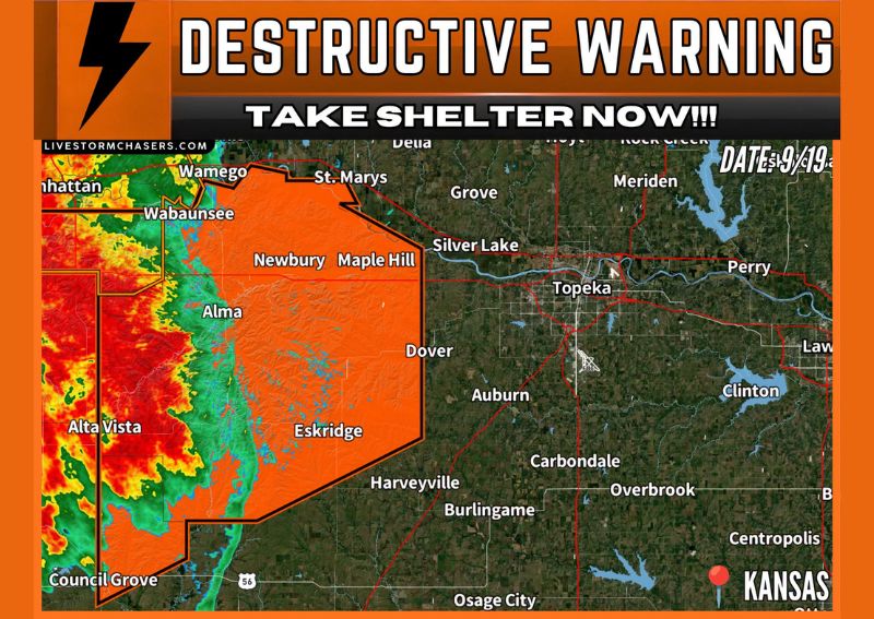
TOPEKA, KS — A destructive thunderstorm warning has been issued for portions of northeast Kansas, as severe thunderstorms were located along a line extending from near Ogden to Wilsey, moving northeast at approximately 40 mph. Forecasters warn that these storms carry the potential for 80 mph wind gusts and quarter-size hail, with Topeka and its surrounding communities directly in the projected path of the advancing line. The storm has a documented history of producing wind gusts around 75 mph, reinforcing concerns about its destructive potential as it continues tracking northeast.
Immediate Threat to Topeka Metro Area
The warning specifically places Topeka, the state capital, directly in the path of the advancing storm line, with radar imagery showing an intense core moving through communities including Alma, Eskridge, and Dover en route toward the metro area. Given the storm’s documented history of producing damaging wind gusts, officials are urging residents throughout the Topeka area to take shelter immediately as the system continues its northeastward trajectory at a steady pace of roughly 40 mph.
Destructive Impacts Already Reported Along the Path
Communities including Alta Vista and Volland have already experienced destructive impacts from the storm as it tracked through the area, according to the warning. This designation as a destructive thunderstorm reflects a higher level of confidence that the storm is capable of producing damaging winds and large hail severe enough to cause significant property damage, going beyond the criteria of a standard severe thunderstorm warning.
Large Hail and Extreme Winds the Primary Hazards
The primary hazards associated with this warned storm are quarter-size hail, capable of denting vehicles and damaging roofing and siding, combined with damaging wind gusts reaching as high as 80 mph. Wind gusts of this magnitude are capable of downing trees and power lines and causing structural damage to buildings, making this combination of hazards particularly dangerous for anyone caught outdoors or in a vehicle as the storm moves through.
Residents Urged to Take Shelter Immediately
Given the storm’s destructive designation and its direct path toward the Topeka metro area, residents throughout northeast Kansas are strongly urged to move to sturdy shelter immediately and stay away from windows until the threat has passed. The storm’s consistent history of producing significant wind gusts throughout its track underscores the importance of taking this warning seriously and seeking appropriate shelter well before the storm’s arrival.
For continuing coverage of severe weather events and critical storm analysis across the United States, visit diamondprowl.com.