

TAMPA, FL — Fall fans across Florida may have something to look forward to. The European forecast model is picking up on the state’s next big cold front, arriving around October 10. Early guidance suggests morning temperatures could drop well below normal across much of the Sunshine State. The Tampa Bay area stands out, with temperatures running as much as 11 degrees below normal. The front is still about 12 days away, so details will almost certainly shift, but the signal is strong enough to keep an eye on as October gets underway.
Tampa Bay Shows the Biggest Temperature Drop
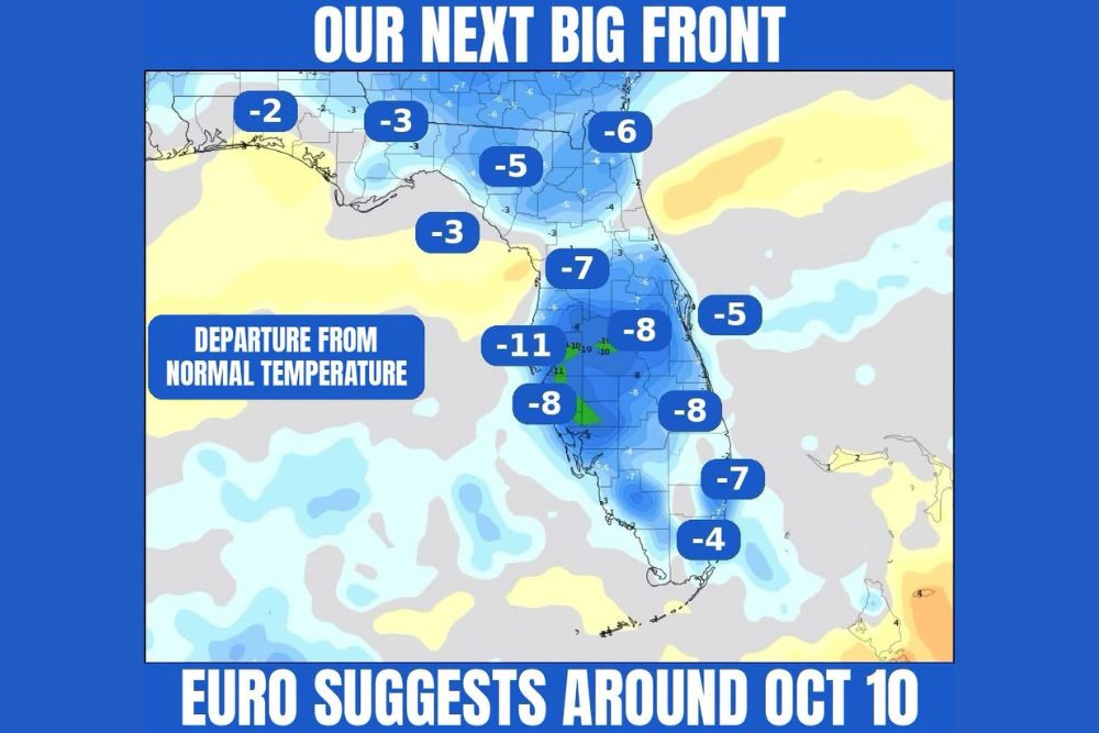
The strongest cooling on the model’s departure from normal temperature map is centered over west-central Florida. The Tampa Bay region shows morning lows up to 11 degrees below normal, the largest departure anywhere on the map. Pockets of deeper cooling of about 10 to 11 degrees also appear just inland from the Tampa Bay area.
For a region where early October mornings usually stay warm and humid, a drop that size would feel like a real change of season. Residents in Tampa, St. Petersburg, Clearwater and Lakeland could wake up to noticeably crisper, more comfortable air if the forecast holds.
Central Florida and Southwest Coast Also Turn Cooler
The cooler air is expected to spread across much of central Florida. The model shows morning temperatures about 8 degrees below normal over the Orlando area and the interior of the Florida Peninsula, and around 7 degrees below normal farther north near the Nature Coast and Ocala region.
Along the Southwest Florida coast, from around Sarasota toward Fort Myers, departures of about 8 degrees below normal show up. On the east side of the state, the Treasure Coast and areas near Lake Okeechobee also show readings about 8 degrees below normal, which points to a broad cooldown across the peninsula.
North Florida and the Panhandle See a Smaller Dip
Farther north, the cooling is still noticeable but less dramatic. The Jacksonville area and Northeast Florida show morning temperatures about 6 degrees below normal, and north-central Florida near Gainesville runs about 5 degrees below normal.
Across the Florida Panhandle, departures are smaller, about 2 to 3 degrees below normal from the Pensacola area through the Big Bend. Nearby parts of southern Georgia and Alabama also show cooler-than-normal readings on the map, a sign that the front’s effects could reach across the wider Southeast.
South Florida Joins the Cooldown
Even South Florida, where cold fronts often lose steam, shows signs of cooler air. The Palm Beach area shows morning lows about 7 degrees below normal. The Miami and Fort Lauderdale areas show departures of about 4 degrees below normal. Along the Space Coast, readings run about 5 degrees below normal.
For South Florida residents, even a few degrees of cooling in early October, along with lower humidity, can make mornings feel much more comfortable after a long, steamy summer.
Still 12 Days Out, So Expect Changes
It’s important to keep this forecast in perspective. The front is still about 12 days away, and long-range model guidance often changes as the date gets closer. The timing, strength and southward reach of the front could all shift in future runs. Small changes in the jet stream pattern could send the front deeper into the peninsula or keep it stalled farther north.
Right now, the European model is showing the signal, and forecasters will be watching whether other models and ensemble guidance agree over the coming days. Consistency across several runs will be key before anyone can be confident.
What Fall Fans Should Watch For
If the front arrives as currently shown, Florida residents could enjoy one of the first true taste-of-fall stretches of the season. That could mean lower humidity, cooler mornings and more comfortable afternoons for outdoor plans, fall festivals, football games and evening events.
For now, residents across Tampa Bay, Central Florida, North Florida and South Florida should keep checking updated forecasts as the October 10 time frame gets closer.
For continuing coverage of Florida’s next big cold front and weather developments across the United States, visit diamondprowl.com.