DENVER, CO — One of the most unusual storm setups of the season could bring strong winds and heavy rain to Colorado’s Front Range on Wednesday. The remnants of former tropical system Polo may stay surprisingly volatile as they cross the Rockies, then spin up like a top once they move east of the mountains. The pattern looks a lot like rapid winter cyclone strengthening, a process that can produce very strong winds along the Interstate 25 corridor. That puts Denver, Fort Collins, Colorado Springs and Pueblo squarely in the zone to watch. Forecasters say the region could be in for one very active week of weather.
A Former Tropical System Spinning Up East of the Rockies
It’s rare for the remnants of a tropical system to regain strength over Colorado, which is what makes this setup so unusual. As Polo’s leftover circulation crosses the Continental Divide and drops onto the Eastern Plains, it could tighten and strengthen quickly. The terrain and the atmosphere east of the Rockies can act like a spinning top, helping the system wind up.
That kind of quick strengthening is more typical of winter storms that blow up over southeastern Colorado. Seeing it happen with a former tropical system in late September is what makes the setup so unusual to meteorologists.
European Model Shows a Tight Low Over Southeast Colorado
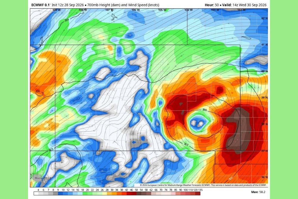
The European (ECMWF) model run from 12z Monday, September 28, shows the setup clearly at the 700-millibar level, roughly 10,000 feet above sea level. Valid at 14z Wednesday, September 30, or about 8 a.m. MDT, the model shows a tight, well-defined low-pressure center over southeastern Colorado east of Pueblo, with a compact wind field wrapped around its center.
A ring of strong winds surrounds the low, with the fastest speeds on its eastern and southern sides. The model’s maximum wind speed at that level is about 58 knots, or roughly 67 mph. Winds of 40 to 50 knots or more extend across much of eastern Colorado and into western Kansas.
Very Strong Winds Possible Along I-25
Winds at the 700-millibar level are not the same as winds at the ground. Still, when a strengthening low sits this close to the Front Range, some of that energy can mix down to the surface. That’s why very strong winds are possible along I-25 on Wednesday, from Fort Collins and Denver south through Colorado Springs and Pueblo.
Strong gusts could bring down tree limbs, knock out power and make driving difficult, especially for high-profile vehicles on I-25, I-70 east of Denver, and highways crossing the Eastern Plains. Leaves are still on the trees this early in autumn, which makes them more likely to catch wind and break.
Heavy Rain Adds to the Threat
Along with the wind, the storm could bring heavy rain to parts of the Front Range and Eastern Plains. Moisture from Polo will be wrapping around the low, and that tropical moisture could produce downpours strong enough to cause ponding on roads and localized flooding in poorly drained areas.
Heavy rain and strong wind together can make conditions especially dangerous. Saturated soils can loosen tree roots, so trees are more likely to fall in strong gusts. Residents near burn scars in the foothills should also be alert for fast-moving runoff.
Part of a Very Active Week of Colorado Weather
This setup comes during an already busy stretch of weather for Colorado. Moisture from Polo is also expected to bring heavy snow to the higher elevations of the central and southern mountains this week, with possible wet snow on I-70 above 9,000 feet between Vail Pass and Silver Plume.
With rain, wind and mountain snow all in the forecast, residents across the state should be ready for rapidly changing conditions.
How to Prepare for Wednesday
Residents along the Front Range should secure outdoor furniture, trash bins, decorations and other loose items before Wednesday. Keep phones charged, have flashlights ready in case of power outages, and give yourself extra time for the commute. Drivers should keep both hands on the wheel in strong crosswinds and watch for debris on roads.
The exact track and strength of Polo’s remnants could still change, which would affect how strong the winds get and where the heaviest rain falls. Check updated forecasts from the National Weather Service offices in Boulder and Pueblo through Wednesday.
For continuing coverage of Polo’s remnants and weather developments across Colorado and the United States, visit diamondprowl.com.