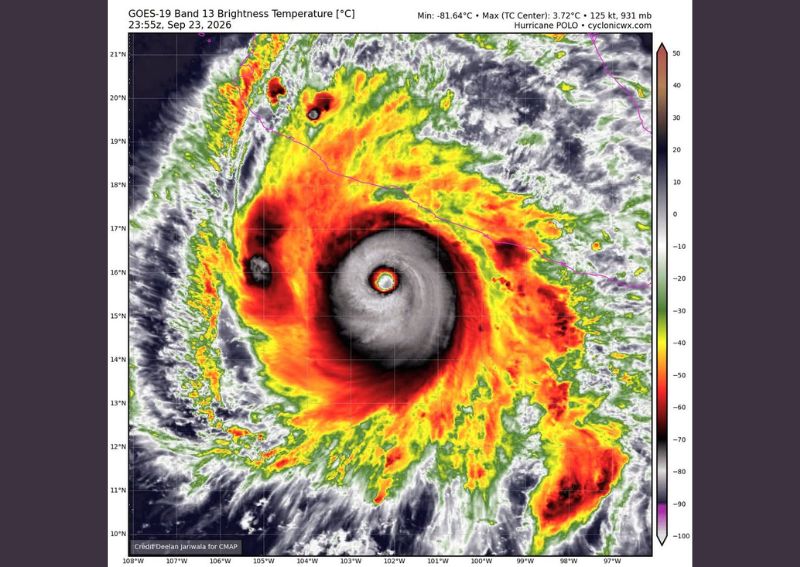
MEXICO CITY, MEXICO — Hurricane Polo remains a powerful Category 5 hurricane off the coast of Mexico, with the latest infrared satellite imagery captured Tuesday night showing the storm maintaining sustained winds of 160 mph and a central pressure of 931 millibars. Meteorologists say the storm’s seemingly supercharged intensity is being driven in significant part by warmer than normal sea surface temperatures tied to the ongoing historic El Niño pattern currently in place across the eastern Pacific.
Satellite Imagery Shows a Textbook Category 5 Structure
Infrared satellite data captured at 23:55 UTC on September 23 shows Hurricane Polo displaying an exceptionally well-defined structure, with a clear, symmetric eye surrounded by an intense ring of the coldest cloud tops, indicative of extremely powerful convection near the storm’s core. The imagery shows brightness temperatures plunging to as low as -81.64 degrees Celsius within the storm’s central dense overcast, a reading that reflects the towering height and intensity of thunderstorms fueling the hurricane’s continued strength.
This kind of textbook satellite presentation, featuring a small, clear eye ringed by intensely cold cloud tops, is exactly what meteorologists look for when assessing a hurricane’s peak intensity and overall organization.
El Niño Linked to the Storm’s Unusual Strength
Meteorologists point to the ongoing historic El Niño pattern as a key contributing factor behind Polo’s remarkable intensity, noting that the warmer than normal sea surface temperatures associated with this climate pattern have helped supercharge the storm’s development. El Niño events are known to influence eastern Pacific hurricane activity by altering sea surface temperature patterns and atmospheric conditions across the basin, often contributing to more favorable conditions for storm intensification during active years.
Beyond its role in fueling Polo’s current strength, meteorologists note that this same El Niño pattern is expected to have broader impacts on the upcoming autumn and winter seasons, though the full extent of those effects remains to be seen as the pattern continues to evolve in the coming months.
Storm’s Intensity Draws Attention Despite No Direct US Impact
While Hurricane Polo currently poses no direct connection to weather conditions in the Pacific Northwest or elsewhere in the continental United States, meteorologists say the storm’s extraordinary intensity alone makes it worth tracking and discussing. Storms reaching sustained winds of 160 mph combined with a central pressure below 935 millibars represent a relatively rare tier of hurricane intensity, occurring in only a small fraction of tropical cyclones each season across any ocean basin.
The storm’s continued strength, even as it remains positioned off Mexico’s Pacific coast, offers meteorologists a valuable opportunity to study how favorable oceanic and atmospheric conditions tied to El Niño can contribute to sustaining peak hurricane intensity over an extended period.
Looking Ahead to a Potentially Active Season
With El Niño conditions continuing to influence the broader Pacific basin, meteorologists are closely watching how the pattern may shape hurricane activity, seasonal temperature trends, and precipitation patterns heading into the coming months. Hurricane Polo’s sustained Category 5 intensity serves as a striking early indicator of just how active and potentially unusual this hurricane season could continue to be as the historic El Niño pattern remains firmly in place across the eastern Pacific.
For continuing coverage of severe weather events and critical storm analysis across the United States, visit diamondprowl.com.