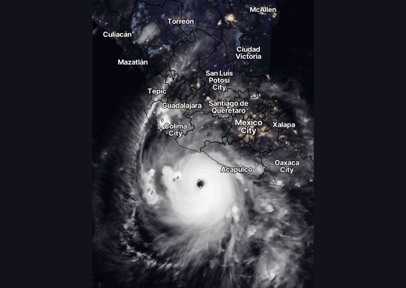
ACAPULCO, MEXICO — Hurricane Polo has restrengthened back into a Category 5 storm off the southern coast of Mexico near Acapulco, producing breathtaking satellite imagery early Thursday morning that captured the storm’s renewed intensity in dramatic detail. Adding to the significance of the moment, Polo now appears to be on a potential collision course with a second major system, Hurricane Odalys, setting up a rare and closely watched scenario involving two powerful hurricanes in close proximity to one another.
Polo Regains Category 5 Intensity
Satellite imagery captured at 8:45 AM Thursday, and updated shortly after at 8:58 AM, shows Hurricane Polo displaying the classic hallmarks of a Category 5 hurricane, including a well-defined, symmetric eye surrounded by intense, deep convection extending outward in all directions. The storm’s renewed strengthening back to Category 5 intensity marks a significant redevelopment for Polo, which had already made headlines in recent days for its historic rapid intensification and record-setting low pressure readings earlier in its lifecycle.
This kind of restrengthening back to peak Category 5 intensity after a storm has already reached that threshold once is a notable meteorological event in its own right, often reflecting a storm’s continued interaction with exceptionally warm ocean waters and favorable atmospheric conditions that allow it to maintain or rebuild its most intense structure.
Storm Positioned Just South of Acapulco
The latest satellite view places Polo’s core positioned just south of Acapulco, with the storm’s outer bands and associated thunderstorm activity extending across a broad area of the eastern Pacific off Mexico’s southern coast. Communities including Acapulco, Oaxaca City, and the surrounding coastal region remain within reach of the storm’s potential influence, even as Polo’s exact forecast track continues to be refined by meteorologists monitoring the system closely throughout the morning hours.
The storm’s positioning relatively close to the Mexican coastline, combined with its renewed Category 5 intensity, has elevated the level of attention being paid to Polo’s next movements among both meteorologists and residents throughout the region.
A Potential Collision Course With Hurricane Odalys
Perhaps the most striking development highlighted alongside Polo’s restrengthening is the storm’s apparent trajectory toward a potential encounter with a second hurricane, designated Odalys. When two significant tropical systems track close enough to interact, meteorologists watch closely for what is known as the Fujiwhara effect, a phenomenon in which two nearby cyclones can begin to rotate around a common center, potentially influencing each other’s track, structure, and intensity in complex and sometimes unpredictable ways.
The prospect of two major hurricanes approaching such close proximity represents a genuinely rare meteorological scenario, one that forecasters will be monitoring with particular interest given the added complexity that storm interaction can introduce into an already challenging forecasting environment for either system individually.
Continued Close Monitoring Expected
Given both the renewed Category 5 intensity of Hurricane Polo and its potential interaction with Hurricane Odalys, meteorologists are expected to maintain especially close monitoring of both systems in the hours and days ahead. The combination of an already historic storm regaining peak intensity and the added uncertainty introduced by a potential dual-hurricane interaction makes this an unusually dynamic and closely watched stretch for forecasters tracking tropical activity across the eastern Pacific basin.
Implications for Coastal Communities
With Polo maintaining Category 5 strength in relatively close proximity to Mexico’s Pacific coastline, coastal communities throughout the region are being urged to stay closely tuned to official forecast updates as both the storm’s track and its potential interaction with Odalys continue to evolve. Any scenario involving a Fujiwhara-type interaction between the two systems could introduce meaningful shifts in either storm’s projected path compared to what would be expected if each system were tracking independently, adding an extra layer of complexity for those attempting to anticipate potential impacts.
What Comes Next
Forecasters will be watching closely over the coming hours to determine whether the two hurricanes continue on their apparent converging paths or whether their tracks diverge as the systems interact with the broader atmospheric steering pattern across the eastern Pacific. Regardless of how the potential interaction between Polo and Odalys ultimately unfolds, Polo’s renewed Category 5 status alone ensures the storm will remain a top priority for meteorologists and emergency officials throughout the region in the days ahead.
For continuing coverage of severe weather events and critical storm analysis across the United States, visit diamondprowl.com.