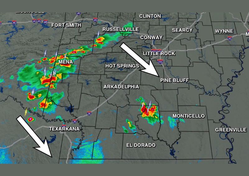
MENA, AR — Forecasters are closely tracking a round of scattered to isolated thunderstorms moving across Arkansas this Monday evening, with radar showing multiple cells stretching from the western part of the state near Mena and Fort Smith southeastward toward Little Rock and Pine Bluff. A few of these storms have reached strong intensity during the evening hours, with gusty winds identified as the primary hazard associated with the activity currently visible on radar.
Strong Winds the Main Concern This Evening
Meteorologists monitoring the developing storm line report that the region has already experienced a few strong thunderstorms this evening, with damaging or gusty winds representing the primary threat rather than large hail or tornadic activity. This kind of wind-dominant severe weather setup is common during periods when storms develop along a boundary with limited overall instability but sufficient wind shear to produce locally strong outflow winds as individual cells mature and collapse.
Radar imagery captured around 6:46 PM shows the most intense storm cores concentrated across the western portion of the state, particularly in the vicinity of Mena, with additional scattered cells extending northeast toward Russellville and southeast toward Arkadelphia. This scattered distribution reflects a somewhat disorganized but still active severe weather setup unfolding across a broad stretch of Arkansas during the evening commute and into the overnight hours.
Storms Drifting Slowly to the Southeast
Forecasters note that the storms currently visible on radar are drifting only slowly to the southeast, meaning the overall movement of the activity across the state is expected to be gradual rather than rapid. This slower storm motion can sometimes allow individual cells to linger over the same areas for an extended period, potentially increasing the localized impact of any heavy rainfall or gusty winds associated with the stronger cells within the broader complex of storms.
Communities in the path of this slow eastward drift, including areas around Hot Springs and Arkadelphia, should anticipate the possibility of encountering these storms as they continue their gradual track across the central part of the state through the remainder of the evening.
Isolated Cells Remain Active Across the State
Beyond the more organized cluster of storms near the western border, radar also shows isolated thunderstorm activity scattered farther south and east, including cells near Monticello and El Dorado in the southeastern part of Arkansas. This kind of widespread but isolated storm coverage suggests that while not every community in the state will experience thunderstorms this evening, meaningful storm activity remains possible across a fairly broad geographic footprint stretching from the western border toward the southeastern corner of the state.
The presence of multiple, separate storm clusters operating somewhat independently of one another reflects an atmosphere capable of supporting scattered convection across a wide area, even without a single, cohesive line of storms tying all of the activity together into one organized system.
Continued Monitoring Through the Evening
Given the ongoing nature of this evening’s storm activity, meteorologists plan to continue closely monitoring radar trends as the scattered cells continue their slow southeastward progression across Arkansas. Residents throughout the state, particularly those in the path of the more intense cells near the western border and along the slow-moving corridor toward Little Rock and Pine Bluff, are advised to stay weather aware through the evening hours given the potential for locally strong, gusty winds accompanying the stronger storms currently on radar.
As is typical with scattered convective activity of this nature, not every location within the broader risk area will experience thunderstorms, but those that do could see brief but locally impactful wind gusts as the storms continue their gradual eastward and southeastward track across the state through the remainder of Monday evening.
Meteorologists emphasize that conditions can change quickly with this type of setup, since individual storm cells can strengthen or weaken over relatively short periods as they interact with varying levels of atmospheric moisture and instability across different parts of the state. Residents are encouraged to keep a reliable way to receive weather updates handy through the overnight hours, particularly in areas along the storms’ projected path where gusty winds remain the most likely hazard through the end of the evening.
Local weather trackers across Arkansas have indicated they will continue providing radar updates as the situation develops, giving residents a continued resource for monitoring the scattered storm activity as it progresses across the state during the remainder of the evening and into the overnight hours.
For continuing coverage of severe weather events and critical storm analysis across the United States, visit diamondprowl.com.