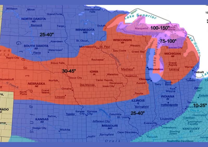
CHICAGO, IL — A newly released winter snowfall outlook is projecting a mixed bag of conditions across the Midwest and Great Lakes region for the upcoming season, with some areas expecting near or slightly above average totals while others, particularly across the far north, face the likelihood of well below average snowfall. The outlook, which covers the period from October through next April, highlights a corridor along and south of Interstate 90 as the best potential zone for significant winter storms, with projected totals ranging between 30 and 45 inches across much of Iowa, southern Minnesota, and southern Wisconsin.
Northern Areas Face Below Average Totals
According to the forecast, the farther north one travels within the outlook area, the more likely conditions are to fall well below the seasonal average, with some locations across North Dakota and northern Minnesota potentially seeing totals as low as 25 to 30 inches for the entire season. A ridge of high pressure expected to set up across the Upper Midwest is the primary driver behind this projected shortfall, as persistent ridging tends to divert storm tracks and limit the moisture and cold air combinations needed for significant snowfall events in that region.
This ridging pattern is also expected to suppress snowfall totals within the traditional lake effect snow belts, meaning even areas that typically benefit from consistent lake-enhanced snowfall could see reduced totals compared to a more typical winter season across the northern Great Lakes.
Periods of Significant Lake Effect Snow Still Expected
Despite the overall below average trend anticipated for the lake effect snow belts, the outlook calls for periods of northwest flow, especially during January and February, that would bring a couple of rather significant lake effect snow events to the region. When these northwest flow periods align with sufficiently cold air masses moving across the relatively warmer waters of the Great Lakes, they can produce locally intense and highly localized snowfall totals, even within a season that trends below average overall for the broader lake effect zone.
Areas closest to Lake Superior and eastern Lake Michigan, including the snow belts of Michigan’s Upper Peninsula, are highlighted on the outlook map with the highest total snowfall projections in the entire region, ranging from 75 to as much as 150 inches for the season, reflecting the outsized role lake effect snow plays in those specific locations regardless of the broader seasonal pattern.
Strongest Storm Track Favors the I-90 Corridor
Farther south, the outlook anticipates a historically favorable setup for significant winter storms, contingent on a strengthening subtropical jet stream combining with sufficient cold air intrusions from the north. Under these conditions, big winter storms become increasingly likely, and the outlook suggests the most probable storm track for the season will run along and south of Interstate 90, encompassing much of Iowa, southern Wisconsin, and northern Illinois.
This corridor is projected to see the season’s best potential for significant snowfall-producing storms, with total accumulations for the October through April period expected to fall between 30 and 45 inches, representing a solidly active winter for that stretch of the Midwest compared to areas farther north within the same broader outlook.
Forecast Comes With Built In Uncertainty
The outlook’s author is careful to frame the projected totals as a rough estimate rather than a guaranteed outcome, emphasizing that not every location within a given zone should expect to receive the exact predicted amount of snowfall. Seasonal snowfall outlooks of this nature are inherently uncertain given the many months separating the forecast from the actual winter season, and individual storm tracks can vary significantly from broader seasonal trends depicted on outlook maps.
Overall, the outlook does not anticipate an unusually extreme or historic winter for snowfall across the region, cautioning that residents should expect only limited periods of sustained snowpack rather than a winter defined by persistent, deep snow cover. This measured framing suggests a winter season with notable individual storm events, particularly across the favored I-90 corridor and the lake effect snow belts, but without the kind of sustained, exceptional snowfall that would define a truly historic winter for the broader Midwest and Great Lakes region.
Residents across the outlook area, from the Dakotas through Illinois and into Michigan, are encouraged to treat these early-season projections as a general guide rather than a precise forecast for any single community, since the coming months of atmospheric pattern shifts will ultimately determine how closely the season tracks with today’s outlook.
For continuing coverage of severe weather events and critical storm analysis across the United States, visit diamondprowl.com.