

PHILADELPHIA, PA — The latest European (ECMWF) model update brings encouraging news for anyone hoping for a dry end to the weekend across much of the Mid-Atlantic and Northeast. The model now shows Sunday’s storm passing well to the south, with the heaviest rain over North Carolina and southern Virginia. Only a few showers may reach the far southern parts of the region. That’s a big change from the GFS model, which earlier showed a much wetter, near-monsoon scenario. The storm is still several days away, but forecasters currently favor the European solution.
European Model Shows a Southern Track
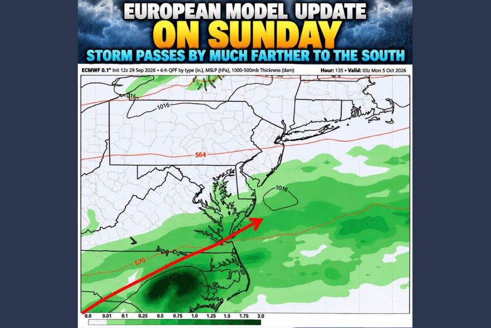
The European model run from 12z Tuesday, September 29, valid at 03z Monday, October 5, or about 11 p.m. EDT Sunday, shows the storm system tracking from the Southeast northeast toward the Atlantic Ocean. It stays south and east of the main population centers of the Mid-Atlantic and Northeast.
The model’s forecast path runs across North Carolina and near the Virginia–North Carolina border before heading offshore. A weak area of low pressure, near 1016 millibars, sits off the New Jersey and Delaware coast. The steadiest rain is spread across the ocean instead of over land.
Heaviest Rain Focused on North Carolina
The heaviest rain in the European model is over central and eastern North Carolina. Six-hour rain totals there reach about 0.75 to 1 inch or more in the most intense pockets. The Raleigh area, the Piedmont and parts of the coastal plain of North Carolina fall inside the wettest part of the forecast.
Lighter to moderate rain also reaches into southern and southeastern Virginia, including areas around Richmond and Hampton Roads, as the storm heads for the coast. That means soggy conditions for much of Sunday across parts of the Carolinas and Virginia.
Only a Few Showers Farther North
Farther north, the European model shows much less rain. Light showers may reach the Delmarva Peninsula, including parts of Maryland’s Eastern Shore and Delaware, and could touch southern New Jersey near the Cape May area. Much of Pennsylvania, central and northern New Jersey, New York and New England stay mostly dry in this run.
For most residents across the Philadelphia, Trenton and New York City areas, that would mean a mainly dry Sunday, with just a few showers possible in the far southern parts of the region.
European vs. GFS: Two Very Different Outcomes
The main difference between the two models is the storm’s track. The GFS model previously showed a much wetter scenario, with heavy rain spreading much farther north across the Mid-Atlantic. The European model keeps the storm suppressed to the south, so most of the region avoids a major soaking.
Forecasters currently lean toward the European solution. The European model has a strong track record of outperforming the GFS, and it handled the recent nor’easter much better. That track record adds confidence to the drier outlook for the northern part of the region.
Plenty of Time for Changes
Even so, the storm is still several days away, and the forecast could shift. A small change in the storm’s track could bring more rain north into southern New Jersey, Delaware and Maryland, or push the rain even farther south and out to sea. Forecasters will be watching upcoming model runs to see whether the European solution holds or whether other guidance starts to agree with it.
Residents with outdoor plans on Sunday, including football games, fall festivals and weekend travel, should keep checking updated forecasts through the week.
What to Watch Through the Weekend
In North Carolina and southern Virginia, residents should be ready for a rainy Sunday, with the chance for heavier downpours, ponding on roads and slower travel along corridors such as Interstate 95, Interstate 85 and Interstate 40. Farther north, conditions currently look much quieter, though a few passing showers can’t be ruled out in far southern areas.
For continuing coverage of Sunday’s storm and weather developments across the Mid-Atlantic, Northeast and the United States, visit diamondprowl.com.