


COLUMBUS, OH — Ohio is in for a round of weather whiplash this week. Light rain moves in Wednesday afternoon, then a stretch of summer-like heat arrives Thursday, followed by more rain Thursday evening into Friday morning. Wednesday starts off mostly dry, with light to occasionally moderate rain pushing into the region after about noon to 3 p.m. The rain clears out by Thursday morning as a warm front lifts north. That opens the door for widespread 80s, with some spots possibly reaching 85 degrees. For one day, October could feel more like July.
Light Rain Arrives Wednesday Afternoon
The first round of rain is expected to be fairly light. Rainfall totals should generally stay at 0.20 inch or less across most of the region. Wednesday morning looks mostly dry, and rain spreads in from the west during the early to mid-afternoon.
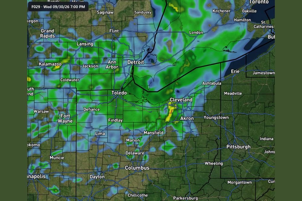
Forecast guidance for 7 p.m. Wednesday shows a broad area of rain across northern Ohio, southeastern Michigan and northeastern Indiana. It covers cities including Toledo, Findlay, Defiance, Lima, Mansfield, Cleveland and Akron, and stretches north toward Detroit and Ann Arbor. Pockets of heavier rain appear near Cleveland and Akron, while areas farther south, including Columbus, Dayton and Chillicothe, see lighter coverage.
Thursday Turns Hot With Widespread 80s
Once the warm front lifts north early Thursday, strong southerly winds will push warm air north into Ohio. Model guidance has increased temperatures sharply, and widespread highs in the 80s are now expected. Some locations could reach 85 degrees.
That’s well above normal for the first day of October, when highs across Ohio usually sit in the 60s to low 70s. Residents can expect a warm, breezy, summer-like day. It’s a good time to open the windows, but also a good idea to stay hydrated if you’ll be active outside.
Heaviest Rain Axis Shifting North Toward Michigan
There’s a big update to the rain forecast. Models are once again shifting the heaviest rain axis farther north toward southern Michigan. If that trend continues, much of Ohio could get less rain than earlier projections showed.
Forecasters are watching the trend closely, and rainfall totals may be adjusted as new model guidance comes in. For now, the heaviest rain looks more likely to fall across southern Lower Michigan, with Ohio closer to the southern edge of the wetter zone.
Much of Thursday Looks Dry
Much of Thursday is expected to be potentially dry across Ohio, which lines up with the warm, breezy conditions. That should make for a pleasant day for outdoor plans, though clouds may increase later in the day.
The tricky part of the forecast comes Thursday evening into Friday morning. That’s when more rain arrives, and it could be the period with the heaviest rain of the entire event.
A Shift of 50 to 100 Miles Changes Everything
Ohio sits very close to the edge of the heavier rainfall zone. A shift of just 50 to 100 miles north or south could completely change rainfall totals across the state.
If the system tracks farther north, much of Ohio could end up with only light rain. If it tracks farther south, areas from Toledo and Cleveland south toward Columbus could get significant rain. Right now, the outcome depends entirely on the storm’s track, and the forecast could range from light rain to a heavy soaking.
Stay Tuned for Updates
Residents across Ohio, southeastern Michigan and northeastern Indiana should keep checking updated forecasts, especially for Thursday night and Friday morning. Commuters should be ready for wet roads Friday morning if heavier rain develops. Anyone with outdoor plans should make the most of Thursday’s warmth before the next round of rain arrives.
For continuing coverage of Ohio’s weather whiplash and weather developments across the United States, visit diamondprowl.com.