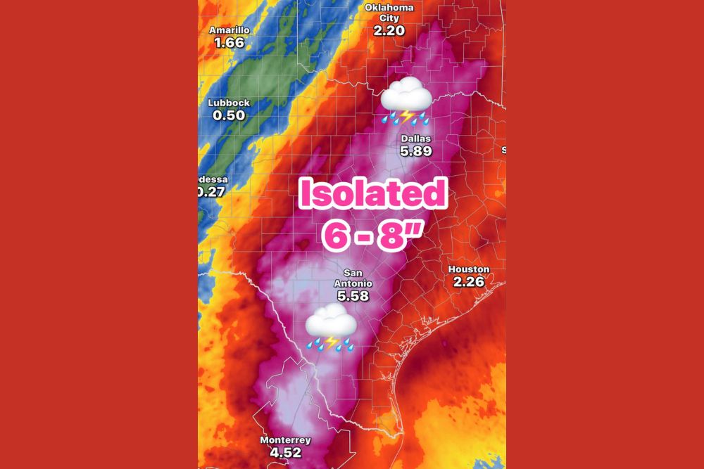
DALLAS, TX — A Flood Watch takes effect at 4 p.m. Wednesday as a multi-inch heavy rain event gets underway across Texas. Forecast data has been consistent in showing heavy rain from late Wednesday afternoon through Friday. Rainfall rates could top 2 inches per hour at times, which could lead to flash flooding. Isolated totals of 6 to 8 inches are possible along a corridor stretching from North Texas through Central and South Texas. The Dallas–Fort Worth and San Antonio areas are expected to be among the hardest hit.
Dallas and San Antonio in the Bullseye
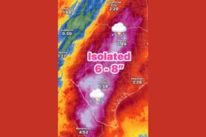
The latest rainfall forecast shows a long band of very heavy rain along the Interstate 35 corridor. Dallas is projected to get about 5.89 inches, one of the highest totals among major cities. San Antonio is close behind at about 5.58 inches.
The heaviest shading on the map covers a wide area between those two cities, including the Waco, Temple, Killeen and Austin regions, as well as the Texas Hill Country. That’s where isolated 6 to 8 inch totals are most likely, especially where storms repeatedly move over the same areas.
Rainfall Rates Over 2 Inches Per Hour
One of the biggest concerns with this event is how fast the rain could fall. Rainfall rates over 2 inches per hour can quickly overwhelm storm drains, flood streets and send creeks and streams out of their banks within minutes.
In urban areas like Dallas, Fort Worth, Austin and San Antonio, where pavement and concrete send water straight into drainage systems, flash flooding can develop fast. Underpasses, low-water crossings and roads near creeks are especially dangerous during intense downpours.
Totals Taper Off to the East and West
Outside the main heavy rain corridor, totals drop off. Houston is forecast near 2.26 inches, and Oklahoma City is projected around 2.20 inches. That’s still a notable amount of rain, but well below the totals expected along I-35.
Farther west, amounts drop sharply. Amarillo is forecast near 1.66 inches, while Lubbock is around 0.50 inch and Odessa only about 0.27 inch. Much of West Texas and the Permian Basin will sit on the drier western edge of the system.
Heavy Rain Extends Into Northern Mexico
The heavy rain band also stretches south across the Rio Grande into northern Mexico. Monterrey is forecast near 4.52 inches. Border communities in South Texas, including areas near Del Rio, Eagle Pass and Laredo, sit near the heavy rain corridor and should also watch for rising water.
The heavy rain across the Hill Country and South Texas raises concern for fast-rising rivers such as the Guadalupe, Frio, Medina and San Antonio rivers, where water levels can climb quickly after heavy rain.
Southern Oklahoma Also in the Path
The heavy rain axis extends north across the Red River into southern Oklahoma. Areas between Dallas and Oklahoma City, including communities near Ardmore and Durant, could see significant totals as the band stretches northeast.
Residents across North Texas and southern Oklahoma should be ready for rounds of heavy rain, thunderstorms and lightning from Wednesday evening through Friday.
Flood Safety Reminders
Residents in the Flood Watch area should prepare now. Clear gutters and storm drains, move vehicles out of flood-prone areas, and make sure phones can receive Wireless Emergency Alerts. Know whether your home, school or workplace is in a low-lying area and have a plan to get to higher ground if needed.
Most importantly, never drive through flooded roadways. Just 12 inches of moving water can sweep away most vehicles, and roadbeds can wash out beneath the surface. Be extra careful at night, when flooded roads are hard to see. Turn around, don’t drown.
For continuing coverage of this heavy rain event and weather developments across Texas and the United States, visit diamondprowl.com.