
COLORADO SPRINGS, CO — A tornado warning was issued for southeastern El Paso County, Colorado, for a storm cell located near Truckton, with the warning based on Doppler radar indications rather than a confirmed visual sighting. The warned storm is tracking south at approximately 15 mph and is expected to remain over rural areas as it continues moving toward the southeastern portion of El Paso County and into northeastern Pueblo County.
Doppler Radar Indicated Rotation
The tornado warning was issued based on Doppler radar indications, meaning meteorologists identified rotational signatures within the storm consistent with tornadic development, even without direct visual confirmation from spotters on the ground. This type of radar-indicated warning is issued when velocity data reveals a strong enough rotational couplet within a storm to meet warning criteria, prompting immediate action from residents in the storm’s projected path.
Storm Tracking Through Rural Terrain
Forecasters noted that the warned storm should stay predominantly over rural areas as it continues its southward track, moving through sparsely populated sections of southeastern El Paso County before reaching northeastern Pueblo County. This rural track is a notable factor in assessing the storm’s overall impact, as the areas expected to be most directly affected have considerably lower population density compared to the more developed corridors near Colorado Springs.
Multiple Storm Cells Active Across the Region
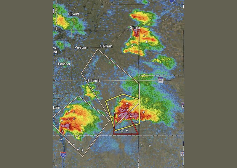
Radar imagery from the time of the warning shows several distinct storm cells active across the broader El Paso County region, including additional cells near Simla and Calhan to the north, along with a separate strong cell tracking near Falcon and Peyton to the west. This widespread storm activity reflects an active severe weather setup unfolding simultaneously across multiple areas of the county during the same general timeframe.
Steady Southward Movement Continues
With the warned cell moving at a relatively steady 15 mph pace toward the south, forecasters continued monitoring its track as it approached the Pueblo County line. Residents in the storm’s direct path, particularly those in the rural stretches of southeastern El Paso County, were urged to take appropriate shelter immediately given the radar-indicated rotation associated with the warning.
For continuing coverage of severe weather events and critical storm analysis across the United States, visit diamondprowl.com.