
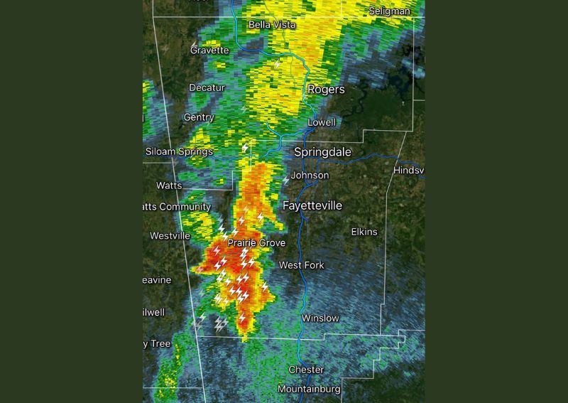
FAYETTEVILLE, AR — A round of loud, active thunderstorms is moving into Northwest Arkansas this evening, with radar imagery showing intense storm cells tracking through the region near Fayetteville and Prairie Grove. These storms currently represent the only active convection in the state, though forecasters note that additional isolated or scattered storm activity remains possible elsewhere across Arkansas as the evening progresses.
Storms Concentrated Across Northwest Arkansas
Radar imagery shows the most intense storm activity concentrated in a corridor running from near Siloam Springs and Watts southeastward through Prairie Grove and toward West Fork, with frequent lightning strikes visible throughout the cell. Communities including Fayetteville, Springdale, and Johnson are positioned along the eastern edge of the most active storm cores, putting residents throughout the metro area in position to experience the noisy, active weather this evening.
Only Storms in the State for Now
Forecasters specifically note that this cluster of storms represents the only active thunderstorm activity across all of Arkansas at this time, highlighting the relatively isolated nature of tonight’s weather event. Despite being limited to this one region for the moment, the storms tracking through Northwest Arkansas are producing intense enough radar returns to suggest locally heavy rainfall and frequent lightning for those directly in their path this evening.
Additional Isolated Activity Remains Possible
While tonight’s storms are currently confined to the Northwest Arkansas region, forecasters caution that additional isolated or scattered storm activity remains possible elsewhere across the state as conditions continue to evolve. This kind of scattered, unpredictable storm development is common during periods of instability, where isolated cells can form with relatively little advance notice in areas beyond the primary zone of organized activity.
Similar Pattern Expected to Continue Tomorrow
Forecasters indicate that the same general pattern is expected to persist into tomorrow, with the potential for additional isolated to scattered thunderstorm activity across Arkansas once again. Residents throughout the state, particularly those in and around Northwest Arkansas, are advised to stay weather aware over the coming day as similar conditions favoring isolated storm development are expected to remain in place.
For continuing coverage of severe weather events and critical storm analysis across the United States, visit diamondprowl.com.