DALLAS, TX — Welcomed soaking rains are on the way for Texas next week, with forecasters pointing to a combination of Hurricane Polo remnants, a disturbance, and a slow-moving front expected to produce heavy rain from Tuesday night through Friday. Leftover scattered showers are expected to linger into next Saturday, delivering exactly the kind of widespread precipitation the state needs to begin making a dent in the ongoing drought.
Major Cities Positioned to See Multiple Inches
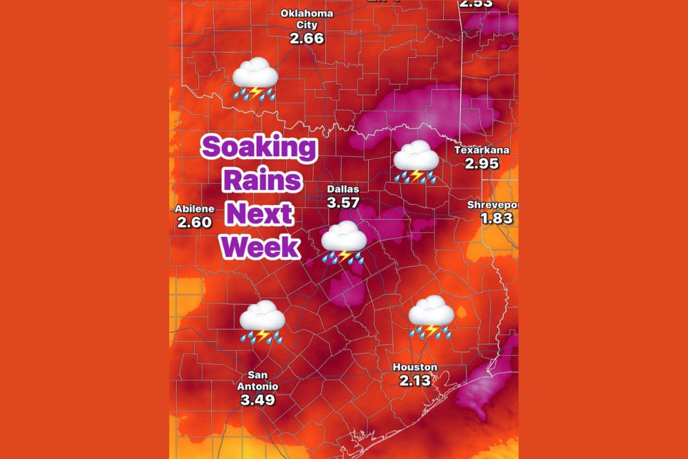
Rainfall projections show several of the state’s largest cities positioned to receive substantial totals over the multi-day event. Dallas is forecast to see approximately 3.57 inches, while San Antonio is projected to receive a similarly significant 3.49 inches. Houston rounds out the major metro totals with 2.13 inches forecast, and Oklahoma City, just across the border, is projected to see 2.66 inches as the system moves through the broader region.
These substantial rainfall totals across multiple major population centers reflect the widespread nature of this incoming system, suggesting the beneficial rain will not be confined to just one corner of the state but will instead deliver meaningful moisture across a broad footprint.
Eastern Texas Sees Some of the Highest Totals
The heaviest projected rainfall totals are concentrated toward the eastern portion of the outlook area, with Texarkana forecast to receive 2.95 inches and pockets of even higher totals shown in the magenta-shaded areas of the rainfall graphic, indicating localized amounts that could exceed 4 inches in some spots. Shreveport, just across the Louisiana border, is projected to see a somewhat lighter total of 1.83 inches, illustrating how rainfall amounts vary even among nearby communities depending on the exact track of the disturbance and front.
A Combination of Systems Driving the Rain Event
Forecasters attribute the incoming rain to a combination of three separate atmospheric ingredients working together: the remnant moisture from Hurricane Polo, an additional disturbance moving through the region, and a slow-moving frontal boundary. When multiple moisture sources and lifting mechanisms combine in this way, it often produces the kind of prolonged, widespread rain event capable of delivering meaningful drought relief rather than a brief, isolated shower that quickly moves through and provides only minimal benefit.
The slow movement of the front in particular is expected to play a key role in extending the duration of the rain event, allowing moisture to linger over the region for multiple days rather than passing through quickly.
Exactly What the Drought Stricken Soil Needs
Forecasters are framing this incoming rain event as precisely what the region needs after an unusually dry summer, emphasizing that the goal extends beyond simply making a dent in the drought to actually saturating soil that has become severely dried out over recent months. Multiple consecutive days of rainfall, rather than a single heavy downpour, tend to be more effective at achieving deep soil saturation, as gradual, sustained rainfall allows water to soak in more thoroughly compared to intense, brief bursts that can run off before fully penetrating dried, compacted ground.
Scattered Showers Linger Into the Weekend
Following the primary rain event running from Tuesday night through Friday, forecasters expect leftover scattered showers to continue into next Saturday, extending the beneficial moisture even further into the following week. This trailing period of scattered activity offers the potential for continued, if lighter, rainfall contributions on top of the substantial totals already expected earlier in the week, further supporting the broader effort to address the ongoing drought conditions across Texas.
For continuing coverage of severe weather events and critical storm analysis across the United States, visit diamondprowl.com.