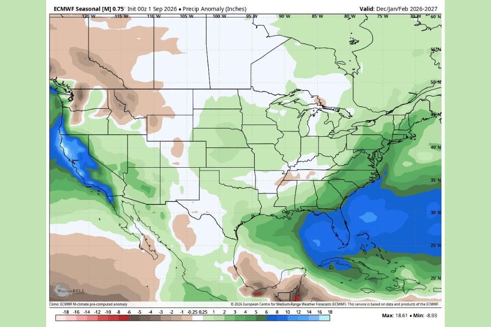
KANSAS CITY, MO — An interesting signal is showing up for the coming winter of 2026–2027. The latest European (ECMWF) seasonal climate model, issued on September 1, 2026, projects a very wet West Coast and East Coast for December, January and February. It also leans slightly wetter than average across much of the central United States. The outlook comes during a winter expected to be shaped by a strong or super El Niño. Historically, El Niño winters have split evenly between drier-than-average and wetter-than-average conditions across parts of the country’s interior. A wet pattern could also mean more snow or ice than expected, even if the winter runs warmer than normal.
West Coast Shows the Strongest Wet Signal
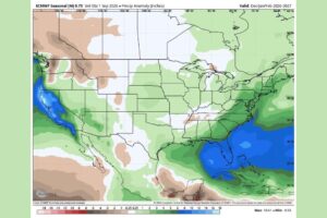
The most striking feature on the ECMWF seasonal precipitation anomaly map is a band of deep blue along the Pacific Coast. Northern and central California, Oregon and Washington show some of the largest projected precipitation surpluses in the country, a sign of a very wet winter for the West Coast.
Wetter-than-normal conditions also stretch inland across parts of Nevada, Arizona and Utah, and into the southern Rockies. A wet signal like this on the Pacific Coast is often linked to a strong El Niño, when an active subtropical jet stream steers repeated storm systems toward California and the West.
Florida and the Southeast Coast Also Look Very Wet
On the other side of the country, the model shows another large area of above-normal precipitation centered over Florida, the eastern Gulf of Mexico and the waters off the Southeast Coast. Florida, southern Georgia, South Carolina and North Carolina all fall within the wettest part of the outlook in the East.
The wet signal continues northward along the Atlantic Seaboard through Virginia, Maryland, Delaware, New Jersey, Pennsylvania, New York and much of New England. The Texas Gulf Coast and Louisiana also show above-normal precipitation, which is typical of a strong El Niño, when storms track across the southern tier of the country.
Central States Lean Slightly Wetter
Across the central United States, the outlook shows a slight lean toward wetter-than-average conditions. That includes much of the Plains, the Midwest, the Great Lakes and the Ohio Valley, covering states such as Kansas, Nebraska, Missouri, Iowa, Illinois, Indiana, Ohio, Michigan and Kentucky.
This is notable because El Niño usually means more rain and less snow across parts of the interior, though that isn’t always the case. A wetter pattern during a winter that runs warmer than normal can still bring more snow or ice than expected when cold air arrives at the right time.
Drier Pockets Across the Northern Rockies and Tennessee Valley
Not every region is expected to be wet. The outlook shows drier-than-average pockets across the northern Rockies, including parts of Idaho, Montana and Wyoming, as well as parts of the Great Basin. A small dry area also shows up near the Tennessee Valley in northern Alabama and southern Tennessee, along with a narrow dry spot near Michigan’s Upper Peninsula.
Southern Arizona and much of northern Mexico also show drier-than-normal conditions. The upper Midwest, including parts of Minnesota and the Dakotas, shows little change from average.
Why El Niño Winters Can Surprise
Past winters with a strong or super El Niño have not all followed the same pattern. In some areas of the interior, about half were drier than average and half were wetter than average. That split shows why seasonal forecasts need to be read carefully and why local outcomes can vary a lot from one El Niño winter to the next.
While El Niño typically favors a milder winter across the northern United States, a steady stream of moisture can still lead to significant snow or ice events when storms line up with cold air outbreaks.
More to Watch as Winter Approaches
Seasonal outlooks show general trends over several months. They are not forecasts for specific storms or days. The ECMWF model will be updated monthly, and forecasters will be watching how the El Niño signal changes through the fall. Residents across the West Coast, East Coast and central states should keep an eye on future updates as winter gets closer.
For continuing coverage of the winter outlook and weather developments across the United States, visit diamondprowl.com.