

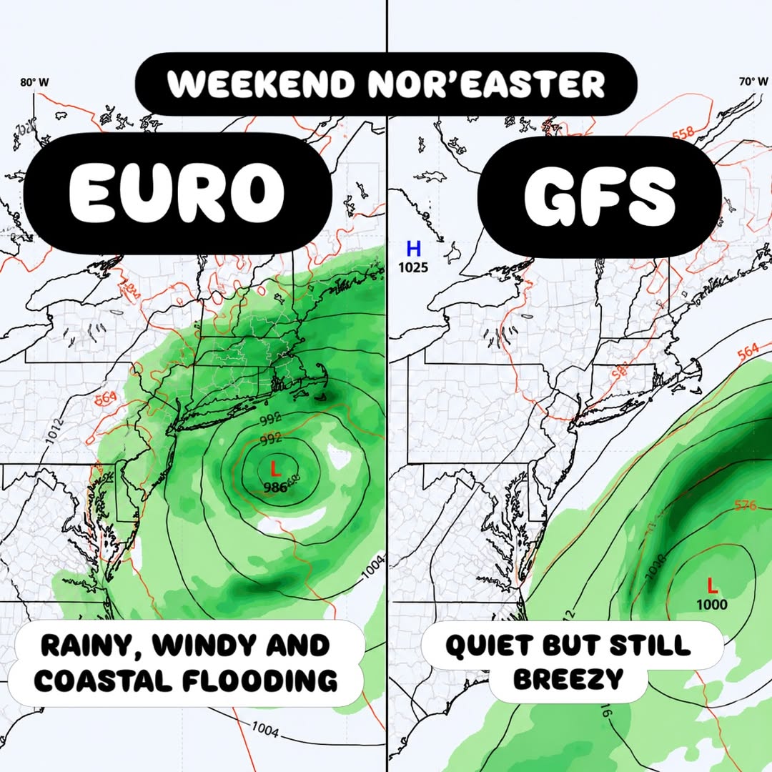
TRENTON, NJ — All eyes are on the upcoming weekend as forecasters track a developing Nor’easter that could bring significantly different outcomes for New Jersey and the greater New York area depending on which model guidance ultimately verifies. The European model currently paints a much more aggressive picture, showing inches of rain, wind gusts exceeding 50 mph, and the potential for coastal flooding and beach erosion along the region’s shoreline as a developing area of low pressure tracks close to the coast this weekend. The American model, meanwhile, offers a far less dramatic outlook, setting up one of the more notable forecast disagreements of the young season.
European Model Shows Direct Coastal Impact
According to the latest European model guidance, the developing Nor’easter would track close enough to the New Jersey and New York coastline to bring substantial impacts, with a central pressure as low as 986 millibars indicating a potentially powerful storm system taking shape offshore. This scenario depicts widespread rainfall totaling multiple inches in some areas, sustained winds capable of producing gusts over 50 mph, and conditions conducive to coastal flooding and shoreline erosion, particularly during high tide cycles over the weekend period.
Communities along the immediate coastline, including barrier islands and low-lying shore towns, would face the greatest exposure if this more aggressive solution ultimately verifies as the storm approaches. Rainfall under this scenario could also lead to localized inland flooding, especially in areas that have already seen wet conditions in recent weeks, compounding the overall impact of the system beyond the immediate coastline.
American Model Suggests a Much Quieter Outcome
In sharp contrast, the GFS, commonly referred to as the American model, depicts more of an out-to-sea scenario for the same weekend system. This version of the forecast shows the storm’s low-pressure center, near 1000 millibars, tracking farther offshore and well away from the immediate coastline, resulting in generally quiet skies across New Jersey and New York with only breezy conditions rather than the direct rain and wind impacts shown in the European model’s more aggressive solution.
Under this scenario, residents would still notice elevated winds and choppier surf, but the disruptive rainfall and flooding potential highlighted in the European guidance would largely stay offshore, allowing most weekend outdoor plans to proceed with only minor adjustments for wind.
Significant Model Disagreement Creates Forecast Uncertainty
The stark contrast between the two leading global weather models underscores the genuine uncertainty still surrounding this weekend’s forecast. With one model showing a direct hit bringing rain, wind, and coastal flooding, and the other showing the storm largely staying out to sea, meteorologists say there remain a few more days to fine-tune the forecast before confidence in either scenario significantly increases heading into the weekend.
This kind of pronounced model disagreement is not unusual several days out from a developing coastal storm, particularly when a system’s exact track along the coast will determine the difference between a high-impact event and a relative non-event for coastal communities. Forecasters typically watch for convergence between competing models as a storm draws nearer, since that convergence often signals rising confidence in the eventual outcome.
A Test Case for the Approaching Winter Season
Beyond the immediate weekend forecast, meteorologists note that this particular forecasting challenge could serve as an informative test case heading into the upcoming winter, offering insight into which model has historically shown a better handle on similar storm systems along the Northeast coast. Nor’easters of this type are common during the cold season across the region, and understanding which model tends to perform better in these setups can help forecasters build confidence in future outlooks throughout the winter months ahead.
Meteorologists often track these early-season disagreements closely, since patterns that emerge now can inform how much weight to give each model as more significant winter storms begin to take shape in the coming months.
Forecasters plan to continue closely monitoring both the European and American model guidance as the weekend approaches, providing updates as the forecast picture becomes clearer for residents across New Jersey and New York. Coastal residents in particular are encouraged to stay tuned to the latest updates given the significant difference in potential impacts between the two competing scenarios, since the eventual track of the storm’s low-pressure center will ultimately determine whether this weekend brings a washout with coastal flooding or simply a breezy, cloudy stretch with minimal disruption.
Regardless of which solution ultimately verifies, residents along the Jersey Shore and the greater New York coastline are advised to keep an eye on updated forecasts throughout the week, as the storm’s track has the potential to shift meaningfully in either direction before the weekend arrives.
For continuing coverage of severe weather events and critical storm analysis across the United States, visit diamondprowl.com.