
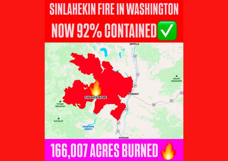
OKANOGAN COUNTY, WA — The Sinlahekin Fire burning in north-central Washington state has seen a significant jump in containment, now standing at 92 percent after having burned a total of 166,007 acres since it began. The fire’s footprint spans a large area of Okanogan County, positioned near the communities of Tonasket and Riverside, with the burn scar extending across terrain near notable landmarks including Tiffany Mountain and Old Baldy.
Significant Progress in Containment Efforts
Fire crews working the Sinlahekin Fire have made substantial progress in recent reporting, pushing containment to 92 percent after weeks of active suppression efforts across the rugged terrain of north-central Washington. This level of containment represents a major milestone in the overall firefighting operation, indicating that the vast majority of the fire’s perimeter has now been secured, even as crews continue working to fully extinguish the remaining active areas.
Fire Footprint Spans Large Portion of Okanogan County
The Sinlahekin Fire’s burn area covers a substantial portion of Okanogan County, with the fire’s perimeter stretching across a wide swath of terrain between Tonasket and the surrounding mountainous areas. The total burned area of 166,007 acres places this fire among the more significant wildfire events in the region this season, reflecting the scale of resources and time that have gone into managing and containing the blaze.
Nearby Communities and Landmarks Within the Fire Zone
The fire’s mapped perimeter extends near several notable geographic features in the region, including Tiffany Mountain and Old Baldy to the fire’s southwest, as well as areas close to Mount Bonaparte to the east. Communities including Tonasket, Oroville, and Riverside sit along the eastern edge of the affected zone, with U.S. Route 97 running through the corridor adjacent to the fire’s footprint throughout much of the affected area.
Containment Milestone Reflects Sustained Firefighting Effort
Reaching 92 percent containment on a fire of this scale reflects a sustained, multi-week firefighting effort involving significant coordination across the affected terrain. As containment levels climb toward full containment, fire management teams typically shift additional resources toward monitoring the secured perimeter and addressing any remaining hot spots, while beginning to plan for the eventual transition out of active suppression operations for the Sinlahekin Fire.
For continuing coverage of severe weather events and critical storm analysis across the United States, visit diamondprowl.com.