

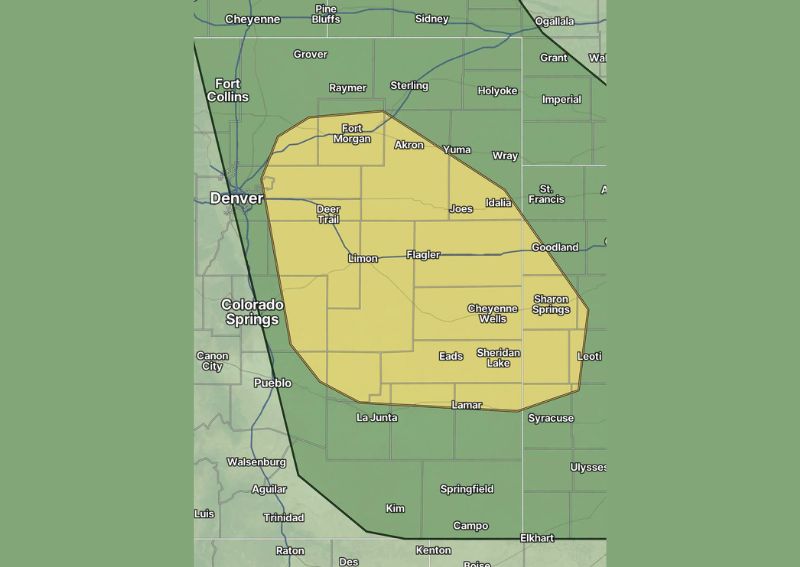
DENVER, CO — A round of potentially strong thunderstorms is expected to develop across eastern Colorado on Saturday, with forecasters warning that damaging winds and large hail are the primary hazards as the system moves through the region. A distinctly shaped severe weather outlook zone covers a broad stretch of the state’s eastern plains, including areas around Fort Morgan, Akron, Limon, and Cheyenne Wells, with additional storm development expected to spread into far eastern Colorado, southwestern Nebraska, and western Kansas later in the day.
Front Range Corridor Faces Afternoon Window
For communities along the Front Range and the Interstate 25 corridor, including areas near Denver, Fort Collins, and Colorado Springs, the primary window for storm development is expected to run from 1 PM to 7 PM. Forecasters note that while damaging winds and large hail remain the main concerns during this timeframe, a brief spin-up or funnel cloud cannot be entirely ruled out if storms manage to organize sufficiently within the outlined risk area.
Eastern Plains See Extended Overnight Threat
Farther east across Colorado’s plains, including communities such as Yuma, Wray, Idalia, and Goodland, the window for potential severe weather extends considerably longer, running from 4 PM until midnight. As storms move off the higher terrain and onto the flatter plains, forecasters expect them to organize into a more cohesive line, with the primary threat increasingly shifting toward widespread damaging wind gusts as the system progresses through the evening hours.
Threat Expands Into Nebraska and Kansas Overnight
As the storm complex continues tracking eastward overnight, the damaging wind threat is expected to expand into far eastern Colorado, southwestern Nebraska, and western Kansas, affecting communities including St. Francis, Sharon Springs, and Leoti. This overnight extension of the risk area reflects how organized line-type storm systems can maintain or even strengthen their wind threat as they move away from their point of origin and gather additional energy from the surrounding atmosphere.
Residents Urged to Stay Weather Aware
With the risk area spanning multiple states and extending well into the overnight hours, forecasters are urging residents across the outlined zone to remain alert to changing conditions throughout the day and evening. Given the potential for a line of storms capable of producing widespread damaging winds and large hail, those in the path of developing cells are advised to have a way to receive warnings and take shelter quickly should severe weather approach their location.
For continuing coverage of severe weather events and critical storm analysis across the United States, visit diamondprowl.com.