
ATLANTIC CITY, NJ — A critical window has been identified for the Nor’easter currently impacting the Jersey Shore, with forecasters pinpointing a period when the actual center of the storm is expected to push onshore or move very close to the coastline. That window, running from approximately 8 to 9 PM Saturday through 8 to 10 AM Sunday, is when the heaviest windswept rain from this storm will affect the region.
A Defined Window for the Storm’s Closest Approach
Meteorologists have identified a specific timeframe during which the storm’s center will either make landfall or track close enough to the Jersey Shore to produce its most intense effects. This window, spanning roughly 8 to 9 PM Saturday to 8 to 10 AM Sunday, represents the period when the combination of the storm’s proximity and its associated wind field is expected to generate the heaviest rainfall rates along the immediate coastline.
Identifying this kind of specific window is particularly valuable for coastal residents, as it allows for more targeted preparation ahead of the storm’s most intense phase rather than treating the entire multi-day event as uniformly severe.
Future Radar Shows Intense Rainfall Along the Coast
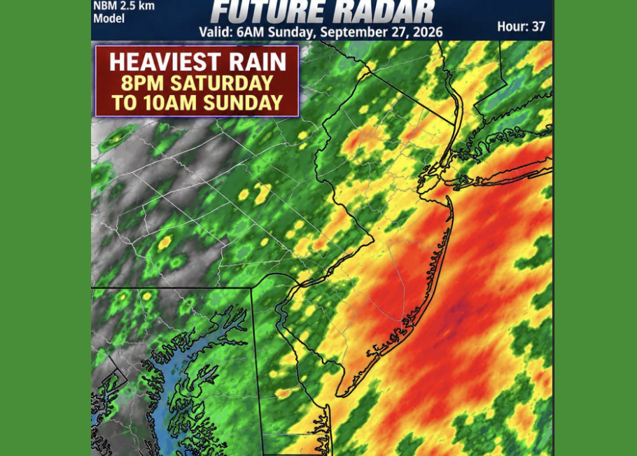
Model-based future radar imagery valid for 6 AM Sunday, September 27, shows a striking band of intense rainfall running directly along the Jersey Shore coastline, extending from the northern shore points down through the southern coastal counties. The imagery displays deep red and orange coloration concentrated almost entirely along the immediate coast, indicating the heaviest rainfall rates are expected to track directly along the shoreline itself rather than spreading evenly across the interior of the state.
This tight concentration of intense rainfall along the coast, visible even in a model projection extending 37 hours into the future, underscores how closely the storm’s most significant impacts are expected to track with the coastline during its closest approach.
Inland New Jersey Sees Lighter but Still Notable Rain
While the coastal corridor is projected to see the most intense rainfall, the future radar imagery also shows meaningful precipitation extending across inland New Jersey, including areas around Trenton and stretching toward the Delaware border. These inland areas show a mix of green and yellow shading on the radar projection, indicating moderate rainfall intensity, a noticeable step down from the deep red coloration dominating the immediate coastline but still representing a significant rain event for those communities.
Windswept Rain Adds to Coastal Impact Concerns
Forecasters specifically characterize the expected rainfall as windswept, reflecting the combination of heavy rain occurring alongside the storm’s powerful wind field as its center approaches the coast. This combination of wind-driven rain tends to produce more significant impacts than rainfall alone, as strong winds can drive rain horizontally and complicate both visibility and any outdoor activity along the coast during the height of the storm’s closest approach.
Timing Critical for Coastal Residents
Given the specificity of the identified window, coastal residents throughout the Jersey Shore region are encouraged to plan around the Saturday evening through Sunday morning timeframe when making decisions about travel, outdoor plans, or storm preparations. As the storm’s exact track continues to be refined, this window offers the clearest guidance yet on when the most significant rainfall and wind impacts are likely to affect the immediate coastline before conditions begin to improve later Sunday.
For continuing coverage of severe weather events and critical storm analysis across the United States, visit diamondprowl.com.