CLOVIS, NM — A tornado warning has been issued for Clovis, New Mexico, after strong rotation was detected within a supercell thunderstorm moving northeast toward the area. Radar data shows the storm tracking on a path that appears likely to keep it just west of the city itself, though forecasters emphasize the storm remains close enough to warrant continued close monitoring by residents in and around Clovis.
Radar Confirms Strong Rotation Within the Supercell
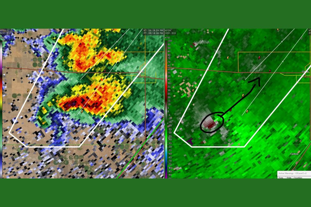
Dual-polarization radar imagery captured during the warning shows the classic signatures meteorologists look for when identifying a potentially tornadic supercell, including a well-defined hook echo feature on reflectivity data and a tight, concentrated couplet on velocity data indicating strong rotation. The velocity imagery in particular shows a compact, intense area of rotation, the kind of signature that typically prompts the issuance of a tornado warning even without direct visual confirmation of a tornado on the ground.
This combination of hook echo and velocity couplet represents a textbook radar presentation for a storm capable of producing a tornado, giving forecasters strong confidence in the warning despite the storm remaining largely over open, rural terrain at the time of issuance.
Storm Track Favors an Area Just West of Clovis
Current radar tracking shows the supercell moving on a northeast trajectory that appears likely to keep the strongest portion of the storm, including the area of rotation, positioned just to the west of Clovis rather than moving directly through the city itself. While this track offers some reassurance for residents within city limits, forecasters caution that the storm remains close enough that any shift in its path could bring the rotation closer to more populated areas with relatively little advance notice.
Supercell thunderstorms can occasionally shift their track unexpectedly as they interact with local boundaries or changes in the surrounding atmospheric environment, meaning residents should not assume the current trajectory guarantees the storm will avoid the immediate Clovis area entirely.
Residents Urged to Monitor the Situation Closely
Given the confirmed strong rotation within the supercell and its proximity to Clovis, residents throughout the warned area are strongly encouraged to have a reliable way to receive updated warnings and to be prepared to take shelter quickly should the storm’s track shift or intensify further. The close proximity of this rotating storm to a populated area underscores the importance of taking tornado warnings seriously even when initial radar tracking suggests the most dangerous portion of a storm may remain just outside city limits.
Continued Monitoring as the Storm Tracks Northeast
Meteorologists will continue closely monitoring the supercell as it maintains its northeast track, watching for any signs of intensifying rotation or a change in the storm’s trajectory that could bring it into closer contact with Clovis or other nearby communities. Given the storm’s already-confirmed rotation and its continued movement toward populated areas, this situation warrants ongoing attention until the tornado warning either expires or the storm’s threat to the region diminishes.
For continuing coverage of severe weather events and critical storm analysis across the United States, visit diamondprowl.com.