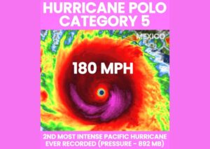

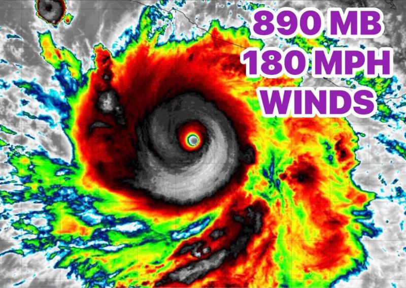
MANZANILLO, MEXICO — Hurricane Polo has undergone explosive intensification off the southwestern coast of Mexico, rapidly strengthening into a Category 5 major hurricane with maximum sustained winds reaching an astonishing 180 mph and a central pressure that has plummeted to 890 millibars. The dramatic strengthening has vaulted Polo into position as the strongest storm anywhere on the planet at this moment, a remarkable transformation for a system that only recently formed as a tropical storm south of Mexico’s coastline.
Explosive Rapid Intensification Documented
Satellite imagery capturing Polo’s evolution shows the hallmarks of an extraordinarily powerful tropical cyclone, with a small, symmetric, and exceptionally well-defined eye surrounded by a nearly perfect ring of intense convection. This kind of pinhole eye structure, combined with the storm’s remarkably low central pressure, is characteristic of tropical cyclones that have undergone rapid intensification, a process in which a storm’s maximum sustained winds increase dramatically, often by 35 mph or more, within a 24-hour period.
Polo’s jump to Category 5 strength with 180 mph winds represents one of the more dramatic intensification events observed in recent years, transforming what began as a much weaker system into one of the most powerful hurricanes recorded in the eastern Pacific basin in a remarkably short timeframe.
Pressure Reading Reflects Extreme Intensity
The storm’s central pressure of 890 millibars stands out as a particularly striking data point, as pressure readings this low are typically reserved for only the most intense tropical cyclones ever observed globally. Lower central pressure generally correlates with stronger sustained winds and a more powerful overall storm, and a reading in the 890 millibar range places Polo among the most intense hurricanes measured in terms of central pressure in recorded history for the eastern Pacific.
This combination of extraordinarily low pressure and maximum sustained winds of 180 mph confirms Polo’s status as an exceptionally dangerous and powerful storm, even as it remains over open water off the coast of southwestern Mexico.
Strongest Storm on the Planet Right Now
With its current intensity, Polo has claimed the distinction of being the strongest tropical cyclone active anywhere on Earth at this moment, surpassing any other tropical system currently churning across any of the world’s ocean basins. This designation underscores just how remarkable Polo’s rapid strengthening has been, elevating what began as a relatively modest tropical system into a globally significant weather event within a matter of days.
The storm’s explosive development has drawn significant attention from meteorologists tracking tropical activity worldwide, given how uncommon it is for a single storm to briefly hold the title of the planet’s strongest active tropical cyclone, particularly one that intensified so rapidly from its initial formation.
Historical Context for a Storm of This Magnitude
Storms reaching Category 5 intensity with sustained winds of 180 mph and central pressures near 890 millibars are exceedingly rare events in the historical record of tropical cyclones. Only a small handful of storms across all ocean basins have ever achieved this combination of extreme wind speed and extraordinarily low pressure, placing Polo in an elite and rarely reached category of tropical cyclone intensity. Meteorologists studying the storm’s rapid evolution will likely spend considerable time in the coming days analyzing the specific atmospheric and oceanic conditions that allowed Polo to intensify so dramatically in such a compressed timeframe.
Favorable conditions for this kind of explosive strengthening typically include exceptionally warm ocean water extending to significant depth, low wind shear allowing the storm’s structure to remain undisturbed, and a moist atmospheric environment supporting sustained deep convection around the storm’s core. The combination of all these factors coming together simultaneously helps explain how Polo was able to achieve such an extraordinary level of intensity in a relatively short period following its initial formation.
What This Means Going Forward
As Polo continues to track through the eastern Pacific, its extreme intensity means that even minor shifts in its forecast path could carry major implications for anyone in its potential path. Storms of this magnitude are capable of producing catastrophic impacts should they make landfall at or near peak intensity, underscoring why meteorologists worldwide are paying close attention to this system despite its current position over open water away from immediate population centers.
For continuing coverage of severe weather events and critical storm analysis across the United States, visit diamondprowl.com.