

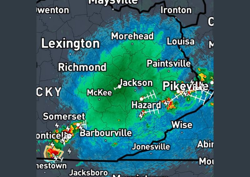
SOMERSET, KY — Multiple clusters of strong thunderstorms moved through eastern Kentucky Sunday night, with weather trackers reporting very loud thunder and heavy rainfall accompanying the storms as of 9 PM Eastern Time. Radar imagery shows widespread precipitation covering much of the eastern half of the state, with the most intense storm activity concentrated in two distinct areas, one tracking south of Somerset and another affecting the Hazard and Pikeville corridor farther east.
Storms Tracking South of Somerset
One of the primary storm clusters tracked through the region south of Somerset, producing frequent lightning and very heavy rainfall as it moved through the area. Weather observers tailing the storm from the ground reported that the thunder associated with this cell was particularly loud, a common characteristic of thunderstorms with strong updrafts capable of producing intense electrical activity alongside heavy rain.
Radar imagery from the time shows this storm cluster positioned near the Kentucky-Tennessee border, with intense reflectivity values indicating heavy rainfall rates within the core of the cell. The storm’s position near Monticello and extending toward the state line suggests it may continue affecting communities along the border region as it continues its track through the evening hours.
Second Cluster Impacts Hazard and Pikeville Corridor
A separate cluster of strong storms was simultaneously affecting the eastern portion of Kentucky, concentrated along a corridor running through Hazard and extending toward Pikeville near the Virginia border. This second area of storm activity showed similarly intense radar returns, with frequent lightning strikes visible across the region as the storms continued tracking through the mountainous terrain of far eastern Kentucky.
The presence of two distinct, separated storm clusters operating simultaneously across different parts of eastern Kentucky reflects an atmosphere capable of supporting multiple areas of strong convection at once, rather than a single organized line of storms affecting the entire region uniformly.
Widespread Rain Blankets Much of Eastern Kentucky
Beyond the two most intense storm clusters, radar imagery shows widespread rainfall covering a broad swath of eastern Kentucky, encompassing communities including Lexington, Richmond, Morehead, and Jackson. While not all of this widespread precipitation reached the same intensity as the two primary storm clusters, the overall coverage indicates a significant rain event affecting a large portion of the state during the evening hours.
This kind of broad precipitation shield often accompanies clusters of strong storms, as the surrounding atmospheric moisture gets drawn into and organized by the more intense convective cells, producing steadier, if less intense, rainfall across the areas immediately surrounding the primary storm activity.
Heavy Rain and Loud Thunder Continue Through the Evening
With both storm clusters continuing to track through their respective areas as of 9 PM, residents across the affected portions of eastern Kentucky should anticipate continued heavy rainfall and frequent, loud thunder through the remainder of the evening. Weather observers monitoring the storms noted the particularly loud nature of the thunder accompanying this system, along with consistently heavy rainfall rates within the more intense cores of both storm clusters.
Residents throughout the broader eastern Kentucky region, including areas near Somerset, Hazard, and Pikeville, are advised to stay weather aware through the evening given the ongoing nature of both storm clusters and the potential for continued heavy rainfall and lightning as the systems track through the area.
Weather trackers will continue monitoring both storm clusters as they progress through eastern Kentucky overnight, with the mountainous terrain of the region sometimes contributing to enhanced rainfall rates as storms interact with the varied elevation across the eastern half of the state. Communities in the path of either cluster should be prepared for brief periods of heavy downpours and frequent lightning as the storms continue their eastward and southward movement through the night.
No severe weather warnings were noted in connection with either storm cluster as of the latest update, suggesting that while the rainfall and thunder have been intense, the storms have not reached criteria typically associated with damaging winds or large hail. Residents can expect the primary impacts to remain centered mainly on heavy rainfall and vivid lightning displays rather than more destructive severe weather hazards as the clusters continue their track across eastern Kentucky this evening and into the overnight hours ahead.
For continuing coverage of severe weather events and critical storm analysis across the United States, visit diamondprowl.com.