
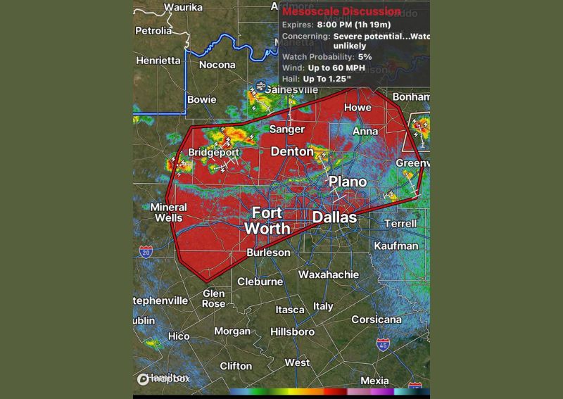
DALLAS, TX — An outflow boundary has moved into the heart of the Dallas-Fort Worth metroplex, triggering the development of widely isolated showers and thunderstorms across the region. A mesoscale discussion issued by forecasters highlights the potential for locally strong wind gusts up to 60 mph and hail as large as 1.25 inches, though the overall probability of a formal severe thunderstorm watch being issued remains low at just 5 percent.
Outflow Boundary Triggers Scattered Development
The outflow boundary, a gust-front-like feature generated by outflow from previous or nearby thunderstorm activity, has pushed into the core of the metroplex, providing enough lift to spark isolated shower and storm development across portions of North Texas. Radar imagery shows storm cells scattered across a wide area extending from Bridgeport and Mineral Wells in the west through Denton, Plano, and Dallas toward Greenville in the east.
One Storm Tracks From Frisco Toward The Colony
Forecasters specifically highlighted one storm cell that developed over the Frisco and Little Elm area, with the cell tracking south toward The Colony through 8 PM. This particular storm represents one of several isolated cells that have formed along the outflow boundary, with its movement pattern consistent with the broader southward drift of shower and storm activity across the northern metroplex during the evening hours.
Severe Potential Remains Limited but Present
While the mesoscale discussion acknowledges some potential for severe weather given the wind and hail parameters outlined, forecasters characterize a formal severe thunderstorm watch as unlikely, assigning only a 5 percent probability to that outcome. This relatively low probability suggests that while isolated stronger cells capable of producing gusty winds or small hail remain possible, widespread organized severe weather is not currently expected across the outlined region.
Wide Coverage Area Spans the Metroplex
The area of concern outlined in the mesoscale discussion covers an extensive stretch of North Texas, stretching from Bowie and Bridgeport in the northwest through Fort Worth and Dallas and extending east toward Greenville and Bonham. Residents throughout this broad zone are advised to stay weather aware through the evening hours as isolated storms continue to develop and track across the region ahead of the 8 PM expiration of the current discussion.
For continuing coverage of severe weather events and critical storm analysis across the United States, visit diamondprowl.com.